
Lappwaldsee
| Lappwaldsee | ||
|---|---|---|

|
||
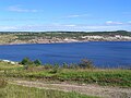
| Lappwaldsee on the city limits of Helmstedt (2011) | ||
| Geographical location | Between Helmstedt and Harbke , Helmstedt district , Lower Saxony | |
| Location close to the shore | Helmstedt | |
| Data | ||
| Coordinates | 52 ° 12 '23 " N , 11 ° 0' 53" E | |
|
||
| surface | approx. 200 ha (2015) | |
| length | 4.6 km (final state) | |
| width | 1.7 km (final state) | |
| volume | 122 million m 3 (final state) | |
| Maximum depth | 70 m (final state) | |
| Middle deep | 16 m (final state) | |
|
particularities |
Recreational lake, nascent; Flooded residual hole of a former open-cast lignite mine |
|

The Lappwaldsee (former project name Helmstedt-Harbke-See , sometimes also referred to as Helmstedt-See ) is the name of an emerging recreational lake south of the city of Helmstedt ( Lower Saxony ) and west of the municipality of Harbke ( Saxony-Anhalt ).
description
Where until 2002 the lignite - opencast mines Helmstedt and Wulfersdorf were, is currently being built in the region, a transnational bathing and recreational waters. After the area has been completely charred, the remaining hole will gradually fill up with water. Since there is hardly any surface water available due to the relatively high terrain of this area , the filling with groundwater will take many more decades (first estimate by 2080, more recent forecast including external flooding by 2030).
On September 29, 2011, the council of the city of Helmstedt, in coordination with the municipality of Harbke, decided on the name Lappwaldsee, although the mine area is around five kilometers southwest of the Lappwald . The preliminary usage concept provides for four areas to be combined in a compatible way: swimming, water sports and trend sports, fishing and nature conservation; to this end, each use will have its own spatial allocation. The aim is a gradual interim use, the first step will be the construction of a 16-kilometer hiking and cycling network with viewpoints around the slowly growing lake.
A transnational state horticultural show in the area of the lake was in preliminary planning for 2014 . However, the plans came to nothing.
In the area of the former opencast mine was the village of Wulfersdorf , which, like other places in the Helmstedter Revier, was demolished for opencast mining.
Characteristics of the Lappwaldsee
- Water surface (final level): 400 hectares at 103 meters above sea level
- Maximum dimensions: north-south 4.6 kilometers, east-west 1.7 kilometers
- Maximum water content: 122 million cubic meters
- Maximum water depth: 70 meters, average depth around 16 meters
- Estimated intermediate status around 2015: around 200 hectares of water at 70 meters above sea level
- Estimated duration of water rise: until 2030
Picture gallery

View over the lake to the southeast, July 2007
View over the lake to the southeast, September 2011

Water level forecast (2011)
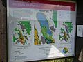
Information board about the creation of the lake

Information board for the Lappwaldsee on the Helmstedter Holzberg with the current fill level indicator


See also
Web links
Individual evidence
- ↑ Website of the city of Helmstedt ( Memento of the original from July 13, 2016 in the Internet Archive ) Info: The archive link was inserted automatically and has not yet been checked. Please check the original and archive link according to the instructions and then remove this notice. , accessed August 5, 2012
- ↑ Feasibility study of the transnational State Garden Show 2014 ( Memento of the original from December 4, 2015 in the Internet Archive ) Info: The archive link was inserted automatically and has not yet been checked. Please check the original and archive link according to the instructions and then remove this notice.