Herøya (Telemark)
| Herøya | ||
 Norsk Hydro works on Herøya |
||
| Geographical location | ||
|
|
||
| Coordinates | 59 ° 6 '45 " N , 9 ° 38' 28" E | |
| Waters 1 | Frierfjord | |
| Waters 2 | Gunneklevfjord, mouth of the Skienselva | |
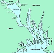
Herøya is the name of a Norwegian peninsula in the area of the city of Porsgrunn in the province of Vestfold og Telemark . It is comprised of the Frierfjord in the west and Gunneklevfjord in the east; the Skienselva river flows here. The name of the peninsula (literally: " Hare Island") is derived from the wild hares that are said to have lived here in large numbers in the past. Today Herøya is considered the largest industrial location in Norway .
In 1929, after only 16 months of construction , the Norsk Hydro Group built a large artificial fertilizer factory and a port for shipping calcium nitrate on a site that had previously only been a few farms . The plant has been operated by the former Hydro subsidiary Yara since 2004 .
After the occupation of Norway in April 1940, the German occupying power had plans to set up aluminum and magnesium factories on Herøya . The almost completed facilities under construction were completely destroyed in a bombing by the Allies on July 24, 1943, killing 55 workers.
In the early 1950s, Hydro took up the old plans and built a magnesium factory on Herøya, which was converted into a modern smelter for scrap metal recycling in 2002 . Hydro has also been producing PVC on Herøya since 1951 .
Today, 30 companies, most of which belong to the Hydro Group, are active on an area of 1.5 km². Among other things, the company's central research department with 350 employees is based on the peninsula. A total of around 2700 people currently work on Herøya.

