
Hexenstein (Lindau)
-2411.jpg)


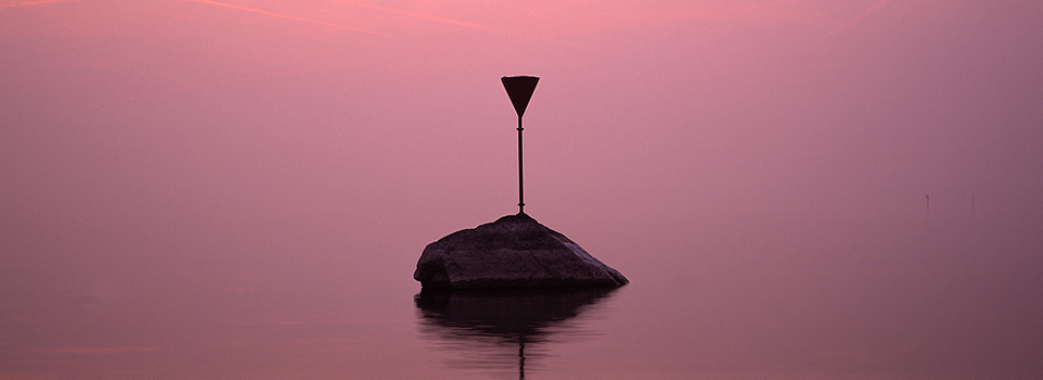
The Hexenstein is a block of gneiss in the Obersee of Lake Constance near the island of Lindau , which reached its current location during the last Ice Age and protrudes slightly above the surface of the water.
geography
The Hexenstein is located 160 meters west of the Lindau railway embankment , where it reaches the island of Lindau, or just under 120 meters west-northwest of the Sternschanze and a good 40 meters north of the so-called rear island in the shallow water.
Depending on the water level, the Hexenstein rises slightly above the water surface, at low water levels over a meter ("three to four feet, and is a popular playground for seagulls ") and is marked as a danger point for shipping with a red sign (E.7 label of the Shallows and shipping obstacles) .
The lake area near the island does not belong to any parcel or district and is therefore already outside the city limits of Lindau. As part of the dump (bank area up to a water depth of 25 meters), the area still belongs to Germany.
The Hexenstein reached its present location as glacial debris from the large Wasserburg-Lindau moraine , as did the Schachener Berg , the Salzfresser and the upper and lower Bergle near Wasserburg , which do not reach the water level, but are nevertheless obstacles to shipping.
Two witch stones
Since there used to be a second Hexenstein near Lindau, there was also talk of the Hexenstein in the plural. To distinguish it from the earlier Kleiner Hexenstein (Hexenstein near the Römerschanze) , the name Großer Hexenstein (Hexenstein near the Sternschanze) was used . On the land map from 1822 (picture below) the second witch stone is drawn in front of the Römerschanze (directly at Lindau harbor) . From this point , which would be within the Roman baths today, nothing can be seen on current maps or aerial photos.
The forecast to put a witch when they fled from Switzerland you ride across the lake with the first step on the small (now defunct) and then on the big Hexenstein and reached the third step, the opposite mainland shore. A legend from the Irish-Scottish missionary days with Gallus and Columban has grown up around the witch stones . Furthermore, it is said in Lindau that the witch stone in front of the Römerschanze still shows the footprint that Aurelia left on her legendary landing.
In a book from 1902 the two witch stones are referred to as erratic blocks . Map with all coordinates: OSM | WikiMap
![]()
Individual evidence
- ^ JN Sepp: Orient and Occident. A hundred chapters on the night side of nature, magic and witchcraft in ancient and modern times. Berlin 1903.
- ↑ a b Alexander Schöpper: Sagenbuch der Bayerischen Lande, second volume: Die Hexensteine bei Lindau. Munich 1852-1853, pp. 29-30 ( digitized version ).
- ↑ According to the Lake Constance shipping regulations , shallows are designated with a downward-facing (mostly red) cone.
- ↑ BayernAtlas aerial photo + parcel map - the witch's stone can be seen in the middle of the picture. A right click on each place shows the district and municipality. The parcel boundaries are shown in yellow.
- ↑ Lake Constance Map 3: National Areas (PDF)
- ↑ Eberhard Graf von Zeppelin: About the new Lake Constance map and the design (relief) of the Lake Constance ground. In: Negotiations of the tenth German Geographers' Day in Stuttgart on April 5, 6 and 7, 1893, Berlin 1893, pp. 79-104 , here p. 102: Rising above and on the large Wasserburg-Lindau moraine, which is literally littered with glacial debris in particular the Hexenstein near Lindau, the Schachener Berg, as well as the Salzfresser and the upper and lower Bergle near Wasserburg as well-known shipping obstacles up to near the water level.
- ↑ Gottfried Schöffmann: Lacus Brigantinus Sive Potamicus. Lake Constance in Latin texts. 2010, p. 46.
- ↑ Josef Scherer: The city on the lake. Lake Constance and the Bavarian Alemannenwinkel. Lindau 1934.
- ↑ E. von Tröltsch: The pile dwellings of the Lake Constance area, Stuttgart 1902 , p. 233
literature
- The witch stones near Lindau. In: Westallgäuer Heimatblätter, magazine of the Verein für Heimatkunde im Westallgäu eV, Volume 6, No. 4, April 1935, p. 32
- Anne Wenk: The Hexenstein and other fairytale stories from old Lindau. Self-published, Lindau 2002 (86 pages).
Web links
Coordinates: 47 ° 32 ′ 54 ″ N , 9 ° 40 ′ 42 ″ E