
Hintersee (Felbertal)
| Hintersee | ||
|---|---|---|

|
||
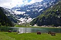
| The Hintersee in the Felbertal near Mittersill | ||
| Geographical location | Oberpinzgau , Austria | |
| Drain | Felberbach | |
| Location close to the shore | Mittersill | |
| Data | ||
| Coordinates | 47 ° 11 ′ 32 " N , 12 ° 28 ′ 32" E | |
|
||
| Altitude above sea level | 1313 m above sea level A. | |
| surface | approx. 5 ha | |
| length | approx. 300 m | |
| width | approx. 200 m | |
| Maximum depth | approx. 70 m | |
|
particularities |
protected natural monument |
|

The Hintersee is a small mountain in 1313 m height in the valley of the Felbertals in Mittersill .
It is about 300 meters long and 200 meters wide. It was created by a landslide in 1495 and has been a natural monument since 1933 . It is fed by meltwater and rainwater from the surrounding mountains of the Hohe Tauern ( Venediger and Granatspitz groups ) and flows off as Felberbach , which flows into the Salzach at the valley exit in Mittersill .
The Hintersee is a popular excursion destination and starting point for numerous hiking trails and high-alpine mountain tours. The steep ascent to the Felbertauern , the apex of the old Säumerweg , which was the most important crossing over the Hohe Tauern even in Roman times, begins from the Hintersee . It was not navigable, but ice-free and could be walked on with pack animals .
Behind the lake at the foot of the Tauernkogel ( 2988 m above sea level ) is the lookout point "Gamsblick" ( 1324 m above sea level ), from where you can not only observe chamois in the wild with the naked eye, but also a unique one Mountain panorama offers. The numerous, very high waterfalls that fall like a veil from the steep slopes at the end of the valley are remarkable. At the "Gamsblick" there is a managed hut on the Hintersee-Alm.
photos
The Hintersee with the Tauernkogel ( 2988 m ) in the background
