Historic Michelbach – Moosbronn – Bernbach border route
| Historic Michelbach – Moosbronn – Bernbach border route | |
|---|---|
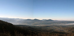
 View from the Bernsteinfels towards the Murgtal and the foothills of the northern Black Forest |
|
| Data | |
| length | 11.3 km |
| location | Gaggenau |
| Starting point |
Michel Bach , recreational facility Gumbe 48 ° 48 '55 " N , 8 ° 22' 11" O |
| Target point |
Bernbach 48 ° 49 ′ 24 ″ N , 8 ° 24 ′ 59 ″ E |
| Type | Themed hiking trail |
| The highest point | 694 m |
| Level of difficulty | light |
| season | all year round |
| Viewpoints | Amber |
| particularities | Round trip possible |
The historic Michelbach – Moosbronn – Bernbach border trail is a hiking trail that follows the course of the former state border between Baden and Württemberg .
history
The history of the Gaggenau districts of Michelbach and Moosbronn and of the Bad Herrenalb district of Bernbach is linked in a special way to the former state border between Baden and Württemberg . The so-called wasp waist of the old state of Baden was on the Michelbacher district . At the narrowest point, it is only 17.2 km from the Württemberg border to the Rhine . A special feature is the state border column in the pilgrimage site of Moosbronn at the point where the state border once ran right through the town.
Since the foundation of the state of Baden-Württemberg and the district reform in 1973 , the communities on both sides of the old border have grown together steadily. An expression of this good neighborhood is now the hiking trail on the trail of the old border, which was signposted by the city of Gaggenau together with the state of Baden-Württemberg.
course
The 11.3 km long hiking trail, lined with numerous boundary stones , begins in Michelbach at the Gumbe leisure facility. The tour leads over the Obere Münzbergweg and the Bernbacher Steige up to the Wasenhütte. If you want to hike the shorter variant, you can turn off here to Moosbronn. The big round leads from the Wasenhütte over the Bernstein , from which there is an impressive panoramic view of the Murgtal, to the Mauzenstein . The path then leads back to the Wasenhütte, to Moosbronn and Bernbach.
information
On the way, 25 boards provide information about the landscape and history of the aforementioned places. Information boxes are located at the churches in Michelbach, Moosbronn and Bernbach.
