Wolterdingen flood retention basin
| Wolterdingen flood retention basin | |||||||
|---|---|---|---|---|---|---|---|
|
|||||||
|
|
|||||||
| Coordinates | 47 ° 58 '25 " N , 8 ° 24' 48" E | ||||||
| Data on the structure | |||||||
| Construction time: | 2006-2011 | ||||||
| Height above the river bed : | 18 m | ||||||
| Building volume: | 300,000 m³ | ||||||
| Crown length: | 460 m | ||||||
| Data on the reservoir | |||||||
| Water surface | 70 ha | ||||||
| Storage space | 4.7 million m³ | ||||||
| Catchment area | 183 km² | ||||||
| Design flood : | HQ 100: 176 m³ / s | ||||||
The Wolterdingen flood retention basin was built between 2006 and 2012 on the outskirts of Donaueschingen- Wolterdingen in the Black Forest-Baar district , Baden-Württemberg .
construction
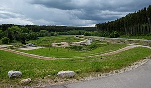
The flood retention basin is intended to improve flood protection on the Breg and Danube. It will significantly reduce the flood peaks of the 100-year flood. It is a dry basin that is only filled when there is high water. The possible storage capacity of the basin is 4.7 million m³. The storage area will then be 70 hectares. The building owner is the state of Baden-Württemberg.
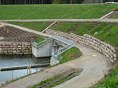
The dam is slightly curved and has a height of 18 m above the river bed. The dam will be built continuously for fish. At normal water levels, these should be able to swim through one of three passages, the so-called eco - tunnels .
history
The groundbreaking ceremony took place on July 13, 2006 . The reinforced concrete work will be carried out from 2006 to 2008, and the hydraulic steelworks from 2006 to 2011 . The dam was dumped from 2008 to 2011. On June 29, 2012, the flood retention basin was put into operation as part of a ceremony. The construction costs are given at 23 million euros.
A trial jam was carried out before Christmas 2012. During this trial jam, a section of the L180 road was flooded, but it survived this process undamaged.
Jams
| date | Hammereisenbach gauge | Pool level | Outlet | Donaueschingen gauge | Remarks |
|---|---|---|---|---|---|
| December 2012 | Test jam | ||||
| 4th-7th January 18 | 03.01. 15:30 pre-alarm 1
04.01. 14:52 pre-alarm 2 04.01. 18:51 blocking of L180 04.01. Start of impoundment 05.01. 03:46 Locked by aluminum inserts 05/06/01 Peak of the filling 07.01. Basin empty again |
||||
| 3rd to 4th February 2020 | Water level reached 7 meters. |
Individual evidence
- ^ A b Donaueschingen: flood dam is about to be tried Badische Zeitung, December 15, 2012, accessed on December 22, 2012
- ↑ Hüfingen: Umschau , Badische Zeitung, December 29, 2012, accessed on May 26, 2013
- ↑ Flood forecast center Baden-Wuerttemberg: water level master data. Retrieved January 7, 2018 .
- ↑ Flood forecast center Baden-Wuerttemberg: water level master data. Retrieved January 7, 2018 .
- ↑ Flood forecast center Baden-Wuerttemberg: water level master data. Retrieved January 7, 2018 .
- ↑ Flood forecast center Baden-Wuerttemberg: water level master data. Retrieved January 7, 2018 .
- ↑ Wolterdingen volunteer fire department : Wolterdingen volunteer fire department. Accessed January 8, 2018 .
literature
- LUBW (Ed.): Passability for animals in rivers, guidelines part 3: Flood retention basins and dams , Karlsruhe 2006, ISBN 978-3-88251-315-8
See also
Web links
- Regional council Freiburg: flood retention basin in Donaueschingen-Wolterdingen
- Leaflet for flood retention basin Wolterdingen / Breg page 1 (pdf; 330 kB) and page 2 (pdf) (322 kB)
- Reinhard Müller: The dam. wolterdingen.de, archived from the original on March 3, 2009 ; Retrieved December 22, 2012 .
- HRB Wolterdingen, Baden-Württemberg
- Youtube video stowage 05.01.18


