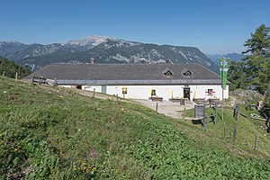
Hofalmhütte
| Hofalmhütte ÖAV refuge category I |
||
|---|---|---|
| Mountain range | Ennstal Alps | |
| Regions | Hall walls | |
| Geographical location: | 47 ° 38 '59.2 " N , 14 ° 22' 16.7" E | |
| Altitude | 1335 m above sea level A. | |
|
|
||
| owner | PES - section Spital am Pyhrn | |
| Construction type | Refuge | |
| Usual opening times | Mid-May to late October | |
| accommodation | 2 beds, 21 camps | |
| Hut directory | ÖAV DAV | |
The Hofalmhütte is located in the municipality of Spital am Pyhrn in Upper Austria , Austria . It is a refuge of Category I of the PES , section Spital am Pyhrn. It is located at 1,335 m above sea level on path 618 from the Rohrauer Haus to the Gowilalm in the Haller Walls . Its location on the edge of a knoll in the debris of the Großer Pyhrgas offers a remarkable 180 ° view from the Warscheneck group to the Sengsengebirge.
history
The Hofalmhütte was built in 1775 as a dairy for the Spital am Pyhrn Abbey . After the monks had moved to the St. Paul Abbey in Lavanttal , the Spital am Pyhrn Abbey and with it the Hofalm became the property of the Religionsfonds in 1809 . After the religious fund was dissolved by the National Socialists, the Hofalm became the property of the Austrian Federal Forests after the Second World War . In 1887, the Windischgarsten section of the Austrian Tourist Club , founded in 1878, set up a straw-filled mattress dorm for five people for the first time in a room in the Hofalmhütte. After a separate section of the Austrian Alpine Association was founded in Spital am Pyhrn in 1905, the Austrian Tourist Club ceded the area east of the main road to the Spitaler, so the Hofalmhütte was transferred to the Alpine Association.
Tour possibilities
- The three-hut hike from the parking lot at the former Grünau inn through the Dr.-Vogelgesang-Klamm to the Bosruckhütte and via the Rohrauer Haus to the Hofalmhütte. From there back to the starting point, total walking time approx. 5 hours
Approaches
- from the parking lot at the Bosruckhütte in approx. 1 to 1½ hours
- from the parking lot at the former Gasthof Grünau ( 725 m ) approx. 2 hours
- from Spital am Pyhrn train station ( 650 m ) in approx. 2½ hours
Mountaineering
- Großer Pyhrgas ( 2244 m ) in approx. 2½ to 3 hours
Transitions to neighboring huts
- to the Rohrau house ( 1308 m ) in about 1 hour
- to the Gowilalm ( 1375 m ) in about 1¾ hours
- to the Bosruckhütte in about 1 hour
Literature & Maps
- Günter and Luise Auferbauer: Gesäuse with Eisenerzer Alps . Hiking guide, Bergverlag Rother , Ottobrunn 2001, ISBN 3-7633-4213-3 .
- Willi End : Gesäuse mountains. A guide for valleys, huts and mountains (= Alpine Club Guide. Nördliche Kalkalpen series. ). Bergverlag Rudolf Rother, Munich 1988, ISBN 3-7633-1248-X .
- Freytag & Berndt u. Artaria KG Publishing and Distribution WK 062 Gesäuse - Ennstaler Alpen - Schoberpass, hiking map 1: 50,000
- ÖK 50, sheet 99 (Rottenmann)
Web links
Individual evidence
- ^ In: Bergauf, magazine of the Austrian Alpine Association; 04. 2019 (No. 4119, vol. 74)

