Homathko River
| Homathko River | ||
|
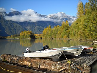
Homathko River not far from the mouth |
||
| Data | ||
| location | British Columbia ( Canada ) | |
| River system | Homathko River | |
| Headwaters |
Niut Range ( Pacific Ranges ) 51 ° 42 ′ 39 ″ N , 124 ° 36 ′ 15 ″ W. |
|
| Source height | approx. 2200 m | |
| muzzle |
Bute Inlet ( Pacific Ocean ) Coordinates: 50 ° 55 ′ 20 " N , 124 ° 51 ′ 1" W 50 ° 55 ′ 20 " N , 124 ° 51 ′ 1" W |
|
| Mouth height | 0 m | |
| Height difference | approx. 2200 m | |
| Bottom slope | approx. 16 ‰ | |
| length | 137 km | |
| Catchment area | 5700 km² | |
| Discharge at gauge 08GD004 A Eo : 5680 km² Location: 12 km above the mouth |
MQ 1958/1962 1973/2016 Mq 1958/1962 1973/2016 |
271 m³ / s 47.7 l / (s km²) |
| Left tributaries | Nostenuko River | |
| Right tributaries | Ottarasko Creek | |
| Flowing lakes | Tatlayoko Lake | |
The Homathko River is one of the major rivers in the southern Coast Mountains in British Columbia and one of the few rivers which the mountain range from the Chilcotin Plateau to the fjords cut.
It rises in the north of the Niut Range , a mountain range of the Pacific Ranges at an altitude of 2200 m . From there it flows down to the Chilcotin Plateau , then turns south and flows through Tatlayoko Lake in a southerly direction. It then cuts through the Coast Mountains , initially in a south-westerly and later in a south-south-east direction, and finally flows into the Pacific Ocean at the end of Bute Inlet opposite the mouth of the Southgate River .
The valley of the Homathko River is very difficult to navigate. The strong current makes it impossible to cross the river. The valley is frequented by grizzly bears .
The catchment area of the Homathko covers an area of 5700 km². The mean discharge 12 km above the mouth is 271 m³ / s. During the ice melting of the glaciers between June and August, the highest discharges are usually measured.
The mountains that flank the Homathko River are among the highest on the Coast Mountains, including Mount Waddington west of the river in the Waddington Range and Mount Queen Bess east of the river, across from the Homathko Icefield .
See also
- Homathko Estuary Provincial Park
- Waddington Canyon
- Great Canyon (Homathko River)
- Homathko River-Tatlayoko Protected Area
Web links
- Homathko River . In: BC Geographical Names (English)
- Homathko Engineering
Individual evidence
- ↑ a b c The Atlas of Canada - Rivers ( Memento from January 22, 2013 in the Internet Archive ) (English)
- ↑ a b c Government of Canada: Water Level and Flow: Station 08GD004
