Hortus
| Hortus | ||
|---|---|---|
|
The mountain range of Hortus |
||
| height | 512 m | |
| location | France | |
| Mountains | Cevennes | |
| Coordinates | 43 ° 47 '39 " N , 3 ° 50' 8" E | |
|
|
||
| rock | limestone | |

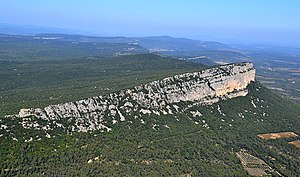
The 512 m high Hortus (also Montagne d'Hortus or Causse d'Hortus , Occitan: Òrtols ) is located in the southern foothills of the Cevennes in the southern French department of Hérault . Its limestone cliff , visible from afar, forms the border between the communes of Rouet in the north and Valflaunès in the south.
location
The striking limestone rock plateau des Hortus is located about 15 km (as the crow flies) north of Montpellier in the area of the communes of Rouet and Notre-Dame-de-Londres , from where there is a road connection (D122) to just below the summit plateau. Opposite the Hortus , the dominant rock peak of the Pic Saint-Loup rises 638 m.
geology
The whole area of the Cevennes and the Causses is made of limestone; it was lifted up from the sea millions of years ago by the tectonic forces of the plate displacement. Since limestone can hardly store water, the area on the surface is quite arid and is only suitable for natural vegetation with dry trees ( garrigue ).
history
It is unclear whether the area - as previously assumed - was already known to the Neanderthals . In any case, numerous stone tools have been found which other researchers have classified as belonging to the period of the Moustérien .
Legend
Legend has it that once two lovers - a shepherd and a shepherdess - fled to the mountains to avoid the girl's marriage to a rich merchant. Chased by dogs, they suddenly stood in front of a towering mountain range. They prayed for help, whereupon a giant living nearby split the mountain with one blow.

