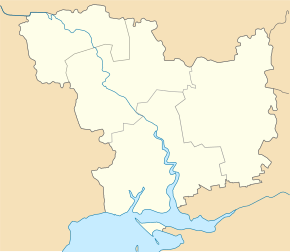
Hurivka
| Hurivka | ||
| Гур'ївка | ||

|
|
|
| Basic data | ||
|---|---|---|
| Oblast : | Mykolaiv Oblast | |
| Rajon : | Nova Odessa district | |
| Height : | no information | |
| Area : | 1.949 km² | |
| Residents : | 1,349 (2001) | |
| Population density : | 692 inhabitants per km² | |
| Postcodes : | 56660 | |
| Area code : | +380 51 | |
| Geographic location : | 47 ° 7 ' N , 31 ° 53' E | |
| KOATUU : | 4824882001 | |
| Administrative structure : | 2 villages | |
| Address: | вул. Центральна 31 56 660 с. Гур'ївка |
|
| Statistical information | ||
|
|
||
Hurjiwka ( Ukrainian Гур'ївка ; Russian Гурьевка Gurjewka ) is a village in the Ukrainian Oblast of Mykolaiv with about 1,350 inhabitants (2001).
The village, first mentioned in writing in 1775, is the administrative center of the district council of the same name in the Nowa Odessa district , to which the village of Pisky ( Піски ⊙ ) with about 730 inhabitants also belongs.
Hurivka lies on the bank of the southern bow . The regional road P-06 running east of the village leads to the district center of Nova Odessa after 25 km to the north and to the city center of the Oblast capital Mykolaiv after 25 km to the south .
Individual evidence
- ↑ Village website on the official website of the Verkhovna Rada , accessed on June 6, 2017 (Ukrainian)

