Dutywa
| Dutywa | ||
|---|---|---|
|
|
||
| Coordinates | 32 ° 6 ′ S , 28 ° 18 ′ E | |
| Basic data | ||
| Country | South Africa | |
| Eastern Cape | ||
| District | Amathole | |
| ISO 3166-2 | ZA-EC | |
| local community | Mbhashe | |
| height | 820 m | |
| Residents | 11,076 (2011) | |
| founding | 1858 | |
|
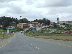
The N2 in Dutywa
|
||
Dutywa (until 2004 Idutywa ) is a city in the South African province of Eastern Cape (Eastern Cape). It is the administrative seat of the municipality of Mbhashe in the district of Amathole . In 2011, 11,076 people lived there.
geography
Dutywa is located on the Dutywa River, a tributary of the Mbhashe River , which flows into the Indian Ocean . The environment is relatively flat. A few kilometers north of the city is the Mangali Forest Reserve. Gcuwa is 35 kilometers south-southwest , and Mthatha is 60 kilometers northeast .
history
In 1858, a fort was built on the site of the present location during the border wars . The name Idutywa comes from isiXhosa and means "place of disorder". In 1884 a settlement was established, which in 1913 received municipal status. The place belonged to the Homeland Transkei , which was reintegrated into the Republic of South Africa in 1994. In 2004 the place was renamed Dutywa.
Infrastructure
The trunk road N2 runs roughly in a north-south direction through the village. Dutywa has a railway connection on the Amabele (near Stutterheim ) –Mthatha line.
sons and daughters of the town
- Thabo Mbeki (* 1942), former President of South Africa
- Moeletsi Mbeki (* 1945), publicist and media manager
- Sithembele Anton Sipuka (* 1960), Roman Catholic bishop
Web links
- Dutywa in 2014 at SABC Digital News (English, isiXhosa; video)
Individual evidence
- ↑ 2011 census , accessed May 4, 2015
- ↑ Portrait at sabc.co.za ( Memento from March 4, 2016 in the Internet Archive ) (English)
- ↑ a b Website of the city ( page no longer available , search in web archives ) Info: The link was automatically marked as defective. Please check the link according to the instructions and then remove this notice. (English), accessed May 4, 2015

