
Transkei
An area in the Eastern Cape of South Africa was designated as Transkei , which was given extensive self-government status as Homeland in 1963 and was given formal state independence by the South African government in 1976 as part of the apartheid policy of the time . Transkei means "beyond kei ". The Kei is a river on the southern border of the Transkei.
geography
Originally and in the European understanding during the colonial period at the Cape, the area later called Transkei comprised settlement areas of some tribal groups of the African population. These were the territories of Fingoland (Mfenguland), Galekaland (Gcalekaland) and Idutywa Reserve . As a result of the immigration of European settlers, under their influence, territorial administrative structures changed several times. Until the last quarter of the 19th century, the term “Free Kaffir Land” or just “ Kaffir Land” was used for this area . However, it is to be distinguished from "British Kaffraria" ( British Kaffraria ), which essentially includes the later Ciskei . The Great Kei River forms the natural dividing line between the two areas and thus the southwestern border of the Transkeiterritoriums . In contrast, the area in the northeast was limited by the course of the Bashee River (now Mbhashe River ) around 1885 ; from its mouth in the Indian Ocean upstream to close to the place Clarkebury / eMgwali (in today's Local Municipality Engcobo ).
The Transkei as "homeland" consisted of three separate areas: a large area between the southeast border of Lesotho and the Indian Ocean, which made up over 90 percent of the area of the Transkei, a small area north of it around Ibisi and an exclave on the southwest corner of Lesotho the places Sterkspruit and Herschel . There were two border crossings to Lesotho. They were operated by the Transkei authorities. The area was 43,800 km² and the population in 1983 was around 1.9 million people, with 2.694 million citizens living in South Africa. The capital and largest town of the Transkei was Umtata (now Mthatha), the only port city of Port St. John's .
The Transkei was one of the less fertile areas of South Africa. Parts of the Drakensberg Mountains with peaks up to 3000 meters above sea level belonged to the territory . The country is criss-crossed by rivers that have their source in the Drakensberg and flow into the Indian Ocean. The stretch of coast is little developed for traffic and is called the Wild Coast (German: "Wild Coast"). Pondoland also belonged to the Transkei .
In the morphology of the terrain, a gradual increase can be seen starting at the coast towards the interior. The narrow coastal belt is followed by the Mittelveld and the Hochveld up to the Great Edge . The landscape in Transkei is predominantly hilly and characterized by agriculture and forestry. Overgrazing and too frequent burning of the vegetation up to the 20th century in connection with unfavorable weather conditions, however, resulted in extensive soil devastation , which predominantly emerged as erosion zones ( dongas ) in the vast meadow landscapes. In other places, in the vicinity of the town of Butterworth , have scree from the Karoo - dolerites formed.
history
Colonial prehistory
The European settlement of the Cape Colony took place for a long time in an easterly direction along the coast, with the resident population being forced to leave their residential areas by settlers and the military. The expansion of the Zulu empire in Natal in the course of the 19th century created pressure to expel the Xhosa population in regions to the west of it. Like part of the white settlers, they lived on cattle breeding and hunting. Due to the resulting geographical opposite development, conflicts over land use and natural livelihoods came to a head. For example, about 5,000 new British settlers arrived in the Eastern Cape at Port Elizabeth between 1820 and 1821 . The political response of the British colonial power to these changes consisted in a fundamental shift in the legal situation for land ownership in the newly conquered areas and in military reactions, such as the so-called border wars and the construction of military fortifications along the external borders of areas under European control. The kei formed the eastern border of the Cape Colony from 1847, as its natural course favored external military security. Until 1894 this border shifted several times within the Transkeian Territories and found its final position through contact with Natal's southwestern edge. The annexation of the then Transkeian Territories took place in the period from 1872 to 1895. In 1857, the administration of the Cape Colony to the west of the Keis settled German legionnaires , as the areas gained by colonial policy were designated as Crown Land and administered according to the European property concept. In the understanding of the tribal population, the land used for livelihood was their common property.
The United Kingdom administered the Transkei area since the 19th century through appointed chiefs ( chiefs ) in a traditionally dominated council system . The Glen Gray Act of 1894 summarized the results of years of colonial development in these areas in a law that was considered an effective tool for attracting cheap labor for the South African economy and increased migrant work at the time of its creation .
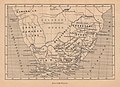
Map of southern Africa (1885) with the entry "Frei-Kaffer-Ld." For the Transkei

Map of the coast of the Eastern Cape (1895) with the entry "Transkei"

.jpg)
United Transkeian Territories General Council from 1931

The old council system of the chiefs was formed in 1931 to a general council ( United Transkeian Territories General Council ), called Bunga , chaired by the white Chief Native Commissioner (German: "Native Chief Commissioner") with 26 white district native commissioners, three co-opted indigenous people Representatives from district councils and four chiefs. This body received a specially designed building ( Chamber and offices of United Transkeian Territories General Council ) in Umtata as its meeting and administrative facility. A similar council was created in 1931 for the Ciskei . In 1951, after the merger of economically unified ethnic groups, the council was supplemented by further regional councils.
Development of self-governing status after 1956
In 1956 , a new territorial authority ( Transkeian Territorial Authority ) with 26 new district administrations ( District Authority ) was set up in place of the United Transkeian Territories General Council , until then the umbrella organization of the self-government built up from the tribes . These changes were made in accordance with the provisions of the Bantu Authorities Act ( Act No. 68/1951 ). All previous administrative structures were repealed by a proclamation (180/1956) with effect from September 1, 1956.
The first meeting of the new territorial authority took place in May 1957. On July 1, L. H. D. Mbuli was appointed the agency's first black Secretary and Treasurer (German: "Secretary and Finance Administrator"). Subsequently, E. W. Pearce took over the post of a supervisory officer (German about: "supervisory officer") of the Bantu administrations in the Transkei. Critics of this development accused the territorial authority of the fact that the chiefs involved in administration lack the necessary educational background to participate in public tasks and deal with public finances. The selection of the people involved in the administrative bodies is therefore not shaped by ability, but by ancestry and a return to tribalism .
For the 1963 election, numerous supporters gathered around Victor Poto, a Paramount Chief , who also had the support of Paramount Chief Sabata Dalindyebo . Another and external group, the Xhosa National Association on the Witwatersrand put up its own candidates, but did not gain any major importance. The supporters of Victor Poto faced a considerable group of people around Chief Kaiser Matanzima . The groups were still not very organized. Outside observers said at the time that the ruling feudal structures would hinder the emergence of political parties. After the election, Victor Poto imagined in the Legislative Assembly ( Legislative Assembly ) a majority of 38 among the 45 selected a total of "deputies" to have. Matanzima, however, assumed 35 of its own supporters. There was a general opinion among the population that a very large majority of the people had supported the politics of Poto. In a closed session of the Legislative Assembly, however, Matanzima received a majority of 54 to 49 votes as a candidate for the post of Chief Minister because he had received many votes from the chiefs (separate mandates for the assembly) in addition to the "deputies". There were 47 chiefs and 7 "deputies" voting for Matanzima, but only 11 chiefs and 38 "deputies" for Poto. This voting behavior represented a previously unseen break with tribal traditions and was viewed critically in and outside the Transkei.
The composition of the Legislative Assembly was also affected by major changes. Initially, the Transkei National Independence Party (TNIP) only won 9 seats out of 45. Several members of the opposition later took the opportunity to cross the floor and joined the TNIP. In addition, a majority of the 64 chiefs supported the TNIP and thereby helped it gain political power. Towards the end of the electoral term, the TNIP had 15 elected officials plus 56 chiefs and the Democratic Party (DP) had 27 elected officials and 8 chiefs. There were also two members of the Transkei People's Freedom Party and one independent.
A provisional government was formed in August. The top posts were occupied by white officials who were to hand over their offices to blacks the following year. Matanzima stated that of the total of 2,476 civil service posts, 1,900 should be filled with blacks immediately. Initially the government was composed as follows:
- Secretary of the Department of Finance, JHT Mills,
- Secretary of the Department of Justice, JH Meyer,
- Secretary of the Department of the Interior, RA Midgley,
- Secretary of the Department of Education, IJM van Rooyen,
- Secretary of the Department of Agriculture, SW Pienaar,
- Secretary of the Department of Roads and Works, WA Grabe.
Since 1963 the Transkei had a formal internal self-government through the Transkei Constitution Act , which prepared the state independence conceived by the South African government.
Establishment of the Bantu state of Transkei
The 1968 election was won by the Democratic Party (DP) under Victor Poto, but the government provided the Transkei National Independence Party (TNIP), which advocated independence for the area.
On September 29, 1976, elections were held in Transkei. The Transkei National Independence Party obtained an absolute majority and received 71 out of a total of 75 electoral seats. In the nominated seats she got 72, so that she was represented by a total of 143 representatives in the 150-seat Legislative Assembly . The New Democratic Party (NDP) and the Democratic Party (DP) each gained three seats and a single independent candidate moved into the assembly.
The Transkei was the first Bantu homeland to be formally given full independence on October 26, 1976. However, this status was never recognized internationally. Botha Sigcau , who died in 1978 and was replaced by Emperor Matanzima , a nephew of Nelson Mandela , took over the office of president . The state language was IsiXhosa , while Sesotho , English and Afrikaans were also permitted as administrative and judicial languages . The Transkei had a parliament that consisted of 75 people-elected representatives, five paramount chiefs and 70 chiefs.
In 1978 the Transkei broke off diplomatic relations with South Africa. The attempt to expel the South African soldiers stationed in the Transkei failed after a short time due to the economic dependence on South Africa. In the 1981 elections, the Transkei National Independence Party won 74 of the 75 seats, and the Democratic Progressive Party , which strongly opposed apartheid, won a seat. So there was virtually no opposition. In 1987, Prime Minister Stella Sigcau was replaced by Bantu Holomisa after a military coup . As a result, the Transkei could occasionally be used as a retreat by members of the African National Congress (ANC). Some of their leaders, such as Nelson Mandela, Govan Mbeki and Walter Sisulu, came from the Transkei. In 1990 a military coup against Holomisa failed; the coup plotters were shot without trial.
Reintegration
With the end of apartheid policy and the first general parliamentary elections in South Africa from April 26th to 29th, 1994, the Transkei was again incorporated into the Republic of South Africa and the South African province of Eastern Cape . Holomisa thus lost his office as president. Today he is a member of the South African parliament for the United Democratic Movement (as of 2017).
Demographics
Of the 6,240,000 Xhosa in 1989, 2,930,000 were formally Transkei citizens, many of them Thembu . Other Xhosa were assigned to the Ciskei.
economy
The main export goods were tea, corn, hides and furniture. Tourism on the Wild Coast was also important. From 1979 state funds were used to build an amusement and bathing center near Mtamvuna on the Indian Ocean , which is still in operation today.
In 1979, the commercial radio station Capital Radio was founded , which cost 4.2 million rand to set up . In 1979, Transkei Airways ordered a Hawker-Siddeley of the type HS 748 for 40 passengers.
The per capita income in Transkei was significantly lower than in South Africa.
In 1979 the South African government had to apply for a loan of 20 million rand, as the Transkei state budget had already been canceled after major projects such as the Mngazana port , or the abandonment of the further expansion of the University of Transkei and the Acquisition of 105 commercial vehicles, did not come to a balanced balance. As part of the loan request in Pretoria, it was proposed to cut the salaries and emoluments of members of the government, state officials, members of parliament, chiefs and headmen. A clear warning in view of the growing problems with the state budget came from D. P. S. van Huyssteen from the Bank of Transkei , who pointed out in the annual report of his bank to the continuing non-recognition of the Transkei by the international community and the associated impediments to the development of the homeland.
The Qamata irrigation system, whose water comes from the Lubisi reservoir and boreholes , was available in Transkei for agricultural water requirements . The reservoir was built in 1968.
Individual evidence
- ^ South African History Online : Transkei . on www.sahistory.org.za (English)
- ↑ Gustav Fritsch : The world part Africa in single representations. IV. South Africa to the Zambezi. 1st department. The country with its vegetal and animal inhabitants . Leipzig, Prague 1885, p. 6
- ^ Census Clarkebury
- ^ HC Schunke: Kaffraria and the eastern border districts of the Cap Colony . Scale 1: 750,000, Justus Perthes , Gotha 1885. In: Petermanns Geographische Mitteilungen , Jg. 1885, plate 9
- ^ PR Irwin, BM Willett, D. Gaylard: Juta's New Large Print Atlas . Juta & Company Ltd., Johannesburg 1985, ISBN 0-7021-1545-2
- ↑ a b c d e Entry Transkei in the Fischer Weltalmanach 1988 . Fischer, Frankfurt am Main 1987, ISBN 3-596-19088-6
- ^ Nick Norman, Gavin Whitfield: Geological Journeys . Struik Publishers, Cape Town 2006, pp. 152-158 ISBN 1-77007-062-1
- ↑ Ernst Klimm, Karl-Günther Schneider, Bernd Wiese: The southern Africa. Republic of South Africa, Swaziland, Lesotho . Scientific country customers. Volume 17. Wissenschaftliche Buchgesellschaft , Darmstadt 1980, pp. 236-237 ISBN 3-534-04132-1
- ↑ Gottfried Wellmer: South Africa's Bantustans. History, ideology and reality . Bonn (Informationsstelle Südliches Afrika eV), 1976, pp. 9–12, 16, 18
- ^ Andrea Lang: Separate Development and the Department of Bantu Administration in South Africa. History and analysis of the special administrations for blacks (work from the Institut für Afrika-Kunde, 103). Hamburg 1999. p. 47, ISBN 3-928049-58-5
- ↑ Ernst Klimm, Karl-Günther Schneider, Bernd Wiese: The southern Africa. Republic of South Africa, Swaziland, Lesotho . In: Werner Storkebaum (Ed.): Scientific country customers. 17, Wissenschaftliche Buchgesellschaft, Darmstadt 1980, p. 43, ISBN 3-534-04132-1
- ↑ Jean Guiloineau (trans Joseph Rowe.): Nelson Mandela: The Early Life of Rolihlahla Madiba . Berkeley 2002, p. 38, ISBN 1-556-43417-0
- ^ Colin Bundy: The Rise and Fall of The South African Peasantry . Cape Town, London 1988, ISBN 0-520-03754-5
- ^ Charles Dundas, Hughes Ashton: Problem Territories of Southern Africa. Basutoland, Bechuanaland Protectorate, Swaziland . South African Institute of International Affairs. Cape Town and London 1952, pp. 70-71
- ^ SAIRR : A Survey of Race Relations in South Africa 1955–1956 . Johannesburg [1957], p. 59
- ^ Nelson Mandela Center of Memory: 1951. Bantu Authorities Act No 68 . on www.nelsonmandela.org (English)
- ^ Apartheid Era Laws: Black (Bantu) Authorities Act No 68 of 1951 . on www.africanhistory.about.com (English)
- ^ SAIRR: A Survey of Race Relations in South Africa 1956-1957 . Johannesburg [1958], pp. 80-81
- ^ SAIRR: A Survey of Race Relations in South Africa 1963 . Johannesburg 1964, pp. 97-98
- ^ SAIRR: A Survey of Race Relations in South Africa 1968 . Johannesburg 1969, p. 142
- ^ SAIRR: Survey 1963 . Johannesburg 1964, p. 99
- ^ SAIRR: A Survey of Race Relations in South Africa 1976 . Johannesburg 1977, p. 243
- ^ SAIRR: Survey of Race Relations in South Africa 1979 . Johannesburg 1980, p. 357
- ↑ SAIRR: Survey 1979 , p. 350
- ^ University of the Western Cape : Lubisi dam . on www.planet.botany.uwc.ac.za (English)
- ↑ Chris Hani District Municipality: Reconciliation Strategy for Chris Hani Cluster 2 Villages . on www6.dwa.gov.za ( Memento from February 18, 2015 in the Internet Archive )

Bophuthatswana |
Ciskei |
Gazankulu |
KwaNdebele |
KwaZulu |
KaNgwane |
Lebowa |
QwaQwa |
Transkei |
Venda
Homelands declared independent by the South African government are written in italics .