Pondoland
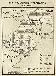
Pondoland (also Mpondoland ) was an area of the former Kaffraria in the British Protectorate Cape Country . Today the area belongs to the South African province of Eastern Cape .
geography
Pondoland is located in what is now South Africa, between Tembuland , Ostgriqualand , Natal and the Indian Ocean . Pondoland was 9267 km². The country is bounded by the Mthatha and Mtanivuna rivers and crossed by the Mzimvubu and numerous other rivers. There are two coastal towns in this area, Port St. Johns and Port Grosvenor .
history
The number of Mpondo , which consisted of many small tribes (Amakwela, Amanyati, Amalana, Amanzi) was about 150,000. Fort Harrison was located above the elongated delta of the mouth of the Umzimvubu .
18th century
On August 4, 1782, the Grosvenor , a British East Indiaman, was shipwrecked off the coast of Pondoland. Only a part of the crew was able to reach European settlements by land. There were fights with local societies. Some passengers, including all women and children, went missing. Port Grosvenor was later opened near the site of the accident.
19th century
Around 1885 the traveler August Einwald and the Baden lieutenant a. D. Emil Nagel to found a colony in German Pondoland . On June 25, 1885, Nagel acquired about 400 km² of land from Umquikela , a chief of the Amapondo. A German Pondoland Society (DPLG) was set up. Representatives of the DPLG received confirmation of the land acquisition from Usigkao, Umquikela's son and successor, on March 10, 1888. The area extended inland from the Wild Coast to a height of about 300 meters. The area claimed for the colony included forest areas such as the Ekossawald. For other sections arable farming was envisaged. Within a few years several German stations for collecting wood samples and for agricultural experiments were set up. These included Located on Umkwenifluss station Lamba and the station located in Germany Intsubana .
See also: section "Pondoland" in the article "German colonial efforts in Southeast Africa"
In view of British claims, however, the German Empire refused the status as a protected area . Instead, Pondoland was placed under British protectorate in 1887 and annexed by Great Britain in 1894. The main town was Palmerton with an evangelical mission station.
20th century
In 1959/1960 an uprising in Lusikisiki was bloodily suppressed by the government in the area of the former Pondoland . There were several deaths. Pondoland belonged to Homeland Transkei, which was formally given independence in 1976 .
Individual evidence
- ^ Meyers Konversations-Lexikon. Vol. 16 Supplements and Register. 3. Edition. Leipzig 1878, p. 456 (entry Kaffern )
- ↑ Agnes M. Hutton: Pondoland - Her Cape And Natal Neighbors 1878-1894. University of the Witwatersrand, Johannesburg 2013 (original from 1935), p. 69 ff.
- ↑ Berthold Volz : Our colonies - country and people. Brockhaus, Leipzig 1891, p. 39, ( online at archive.org ).
- ↑ University of Cape Town: Map of Pondoland with former German stations ( German settlements )
- ↑ Author collective: Meyers Konversationslexikon. 17th (supplementary) volume, 4th edition, Verlag des Bibliographisches Institut, Leipzig and Vienna 1885-1892, p. 665, ( online at retrobibliothek.de ).
- ^ Hugh F. Glen, Gerrit Germishuizen (ed.): Botanical exploration of southern Africa. 2nd ed., Strelitzia 26, South African National Biodiversity Institute, Pretoria 2010, ISBN 978-1-919976-54-9 , p. 83. ( Online at biodiversitylibrary.org )
- ↑ Pondoland. In: Meyers Großes Konversations-Lexikon. Volume 16, Leipzig 1908, pp. 145-146.
- ^ Landesarchiv Baden-Württemberg: Emil Nagel, former lieutenant from Baden: Project on land acquisition in "Pondoland", South Africa
- ↑ Peter Wende: The British Empire - History of a world empire. CH Beck, Munich 2008, p. 201.
literature
- Franz Bachmann : South Africa - travels, experiences and observations during a six-year stay in the Cape Colony, Natal and Pondoland . H. Eichblatt, Berlin 1901, DNB 57912536X .
Web links
Coordinates: 31 ° 16 ′ 0 ″ S , 29 ° 35 ′ 0 ″ E
