Imja Tsho
| Imja Tsho | ||
|---|---|---|

|
||
| Geographical location | Solukhumbu District ( Nepal ) | |
| Tributaries | Imja glacier | |
| Drain | Imja Khola → Dudhkoshi | |
| Data | ||
| Coordinates | 27 ° 53 '53 " N , 86 ° 55' 23" E | |
|
|
||
| Altitude above sea level | 5004 m | |
| surface | 1.03 km² | |
| length | 2 km | |
| width | 650 m | |
| volume | 35.8 million m³ | |
| Maximum depth | 90.5 m | |
| Middle deep | 41.6 m | |

|
||
| Imja Tsho and Imja Glacier | ||
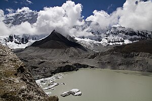
The Imja Tsho is a glacial lake in the Mahalangur Himal , a mountain group in the central Himalayas .
The lake is located in the Solukhumbu district in the Sagarmatha administrative region of Nepal . The Imja Tsho is one of the larger glacial lakes in Nepal. It is located at an altitude of 5004 m (as of 2006). In 1964 the altitude was still 5041 m . Its area is 1.03 km² (as of 2007). It has a length of 2.0 km in a west-east direction. Its width is 650 m. The mean water depth is 41.6 m. The maximum water depth is 90.5 m. The lake has a water volume of 35.8 million cubic meters.
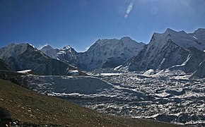
The lake is 7.3 km south of the Lhotse and is framed by the Imja Tse and Num Ri peaks . The Tsho Rolpa is fed on the east side by the Imja glacier . The Imja Khola , a left tributary of the Dudhkoshi , forms the drain at the western end of the lake.
There is a risk that the natural dam that dams the lake could break in the future and trigger a flood event in the downstream areas.

