
Independence Pass
| Independence Pass | |||
|---|---|---|---|

|
|||
| Compass direction | west | east | |
| Pass height | 3686 m | ||
| county | Pitkin County , Colorado ( USA ) | Lake County , Colorado (USA) | |
| Watershed | Roaring Fork River → Colorado River | Headwaters of the Arkansas River → Mississippi | |
| Valley locations | Aspen | Leadville | |
| expansion |
|
||
| Winter closure | First snowfall by May | ||
| Mountains | Sawatch Range ( Rocky Mountains ) | ||
| map | |||
|
|||
| Coordinates | 39 ° 6 ′ 31 ″ N , 106 ° 33 ′ 50 ″ W | ||

The Independence Pass ( Eng. " Independence Pass ") is a mountain pass in the west of the US state Colorado . The pass lies on the border of Pitkin Counties and Lake Counties and connects Aspen with Leadville . The Independence Pass via the Sawatch Range and is located on the North American watershed . The Colorado State Highway 82 crosses the ball.
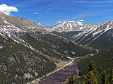
Colorade State Route 82 east of the pass
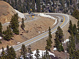
Serpentine in front of the pass
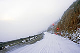
Western pass road when snow drifts in September
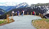
Viewing platform


Web links
Commons : Independence Pass - collection of pictures, videos and audio files