In the sea
| In the sea | ||
|---|---|---|

|
||
| Geographical location | Kazakhstan | |
| Tributaries | none | |
| Drain | none | |
| Location close to the shore | Inderbor | |
| Data | ||
| Coordinates | 48 ° 28 ' N , 51 ° 55' E | |
|
|
||
| surface | 110 km² | |
| length | 13 km | |
| broad | 11 km | |
| scope | 40 km | |
| Middle deep | 0.7 m | |
| Catchment area | 425 km² | |
The Indian Lake (Russian Инде́р or Индерское озеро) is an outflowless salt lake in the northern part of the Atyrau region in Kazakhstan .
Geographical location
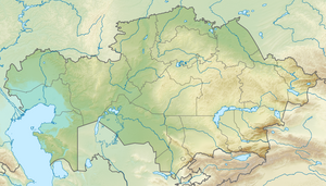
The Indian Lake is located in the northern part of the Caspian Depression , 10 km east of the Ural River . It has an area of 110 km² and its catchment area is 425 km². The shape of the lake is round, slightly elongated from northwest to southeast. The diameter of the lake is 10 to 13.5 km. The lake has no above-ground tributaries. It is fed by salt springs over layers of clay as well as meltwater and rainwater in spring.
10 km northwest of the lake is the urban-type settlement Inderbor , the center of the Indian district in the Atyrau area. In the north and northeast of the lake rise the Indian mountains .
Economic use
As early as the 19th century, Russian geologists showed an increased interest in exploring the lake and its surroundings. At that time it was assumed that the Indian Sea could meet the entire Russian salt requirement; however, due to its inaccessibility, it could not be appropriately exploited. At least at the time, the lake dried up completely at the end of the warm season, and its bottom was covered with a layer of salt.
The lake's water contains high quality salts that contain potassium , bromine and boron . Up to 1.5 million tons of salts (mainly table salt ) are deposited in the lake every year. Crystallized salts are broken down, the thickness of the salt layers is sometimes 10 to 15 m, according to the Kazakh National Encyclopedia even up to 56 m. The clay of the lake bottom is used for medicinal purposes.
The lake, more precisely the boron and salt deposits near its shore, are considered to be the type locality for seven minerals so far (as of 2021): Hydroboracite , Inderborite , Inderite , Kurgantaite , Kurnakovit , Preobrazhenskite and Volkovskite .
flora
In the 19th century, Russian researchers discovered the plant species Eremurus inderiensis from the genus of steppe candles for the first time at Lake Inders .
literature
- Индер , in: Kazakh National Encyclopedia, Almaty, 2005
- Валяшко, Михаил Георгиевич (Waljaschko, Mikhail Georgievich): Изучение физико-химического режима озера Индер и получение солей из его рассолов (study of the physico-chemical regime of Indian Lake and the salt production from its Solen), Dissertation, All-Russian Research Institute of Salt economy, Leningrad, 1943
- Индер , in: Great Soviet Encyclopedia (Russian)
Web links
- Inder Salt Lake enchants with beauty and curing properties, yet remains unexplored. The Astana Times, September 6, 2018, accessed August 1, 2021 .
Individual evidence
- ^ A b Karl Caesar von Leonhard : Rock salt, its occurrence and method of extraction. : German quarterly font , year 1848, p. 351 (online at ANNO ).
- ↑ "Индер" , in: Great Soviet Encyclopedia (Russian)
- ^ Inder B deposit and salt dome, Inder, Atyrau Region, Kazakhstan. In: mindat.org. Accessed August 2, 2021 .
