Ingersheim an der Jagst
|
Ingersheim an der Jagst
City of Crailsheim
|
|
|---|---|
| Coordinates: 49 ° 7 ′ 23 ″ N , 10 ° 4 ′ 30 ″ E | |
| Area : | 5.13 km² |
| Residents : | 1350 (December 31, 2017) |
| Population density : | 263 inhabitants / km² |
| Incorporation : | April 1, 1940 |
| Postal code : | 74564 |
| Area code : | 07951 |
|
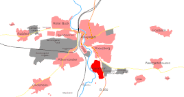
Location of Ingersheim within the Crailsheim city area
|
|
Ingersheim an der Jagst is a district of Crailsheim that formed its own municipality until it was incorporated on April 1, 1940. Despite its location near the city center, it has largely retained its village character.
geography
location
Ingersheim is located in the southeast of the Crailsheim city area between the B 290 in the east and the Jagst in the west. The built-up area extends from north to south for about one kilometer, from east to west it measures about 500 meters at the widest point in a west arch of the Jagst. The old village center is near the river, which it touches at an old mill location and a little below at the road bridge of the K 2642 in the direction of Altenmünster, but otherwise leaves its shallow floodplain free and runs up the slope. The later and more extensive building areas extend to the southeast and north-northeast or along a parallel street to the B 290. Within the soft area there are still areas used for agriculture.
Neighboring places
Ingersheim is surrounded in turn by other Crailsheim suburbs and districts. In the north, beyond a vacant lot less than a hundred meters wide, there is Kreuzberg, about 3.5 km to the east is Westgartshausen, just as much to the south is Jagstheim , about 3 km to the south-west Onolzheim and about 1.5 km to the west Altenmünster .
history
- 1280: Uncertain documentary mention as Ingershain (possibly refers to another place)
- 1329: First secure documentary mention as Ingesheim
- 1612/13: 1st plague epidemic, more than 80 deaths
- 1634/35: 2nd plague epidemic, more than 80 dead again
- 1648: After the Thirty Years War , 60% of the Ingersheim buildings are destroyed.
- 1688: During the War of the Palatinate Succession , the French damage the church and school and burn down a house on the Jagstfurt.
- April 1, 1940: Ingersheim is incorporated. Ingersheim owed its incorporation not to itself, but to the former hamlet of Altenmünster , which belonged to the municipality of Ingersheim and whose settlement expanded over the course of time to the Crailsheim boundary.
- April 1945: Destruction in Untere Gasse, Hauptstrasse and on the Schollenberg
Religions
In Ingersheim there was a small Jewish community until 1832, after which the Jewish residents of the village belonged to the Crailsheim Jewish community.
Today Ingersheim has a Protestant parish, which also includes the hamlet of Alexandersreut and the Rotmühle homestead. The church of the community is called Matthäuskirche, was built around 1450 and got a new nave in 1961/62. In the choir there are frescoes from the 15th, 17th and 18th centuries.
Infrastructure
Public facilities
- Ingersheim gymnasium and festival hall
education
- Geschwister-Scholl-Schule Ingersheim (primary and secondary school)
- A communal kindergarten
traffic
- Connection to the B290
Sons and daughters of the church
- Inge Aicher-Scholl (1917–1998), writer
- Hans Scholl (1918–1943), resistance fighter


