Ireland Island South
| Ireland Island South | ||
|---|---|---|
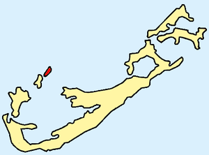
| Location of the islands (Ireland North and South Island) within Bermuda | ||
| Waters | Atlantic Ocean | |
| Archipelago | Bermuda | |
| Geographical location | 32 ° 18 '54 " N , 64 ° 50' 42" W | |
|
|
||
| length | 1.1 km | |
| width | 400 m | |
| surface | 39 ha | |
| Highest elevation | 3 m | |
Ireland Island South is a small island in the extreme northwest of the Atlantic archipelago of Bermuda . It is only separated from its northern sister island Ireland Island North by a 10 meter wide river, which is why both islands occasionally bear the common name Ireland Island .
The connection to the North Island is via a small bascule bridge ( The Cut Bridge ). A 170 meter long bridge connects Ireland Island South with the south-west bordering Boaz Island .
In contrast to the North Island , the South Island is hardly built on. Worth mentioning are the lagoon in the south of the island and a historic cemetery for military personnel from the Royal Navy .
The island is part of the Bermuda administrative area of Sandys Parish .

