Ireland Island North
| Ireland Island North | ||
|---|---|---|
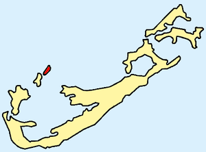
| Location of the islands (Ireland North and South Island) within Bermuda | ||
| Waters | Atlantic Ocean | |
| Archipelago | Bermuda | |
| Geographical location | 32 ° 19 ′ 31 ″ N , 64 ° 50 ′ 9 ″ W | |
|
|
||
| length | 1.3 km | |
| width | 300 m | |
| surface | 44 ha | |
| Highest elevation | 3 m | |
Ireland Island North is an elongated island in the extreme northwest of the Atlantic archipelago of Bermuda . The north island is only separated from its southern sister island Ireland Island South by a river barely 10 meters wide, which is why both islands are known under the common name Ireland Island .
The once uninhabited island was probably discovered by Spanish sailors as early as the 16th century , but was not taken over by Great Britain until the beginning of the 18th century . Because of its strategic location, the British built a shipyard for their naval forces ( Royal Navy ). From this period, some classicist buildings of the Royal Navy Dockyard are still preserved. On the northern tip of the island is the Maritime Museum , where wreckage from ships that have sunk off Bermuda is exhibited.
Ireland Island North is now predominantly built up with commercial buildings. The island's large commercial and marina are on the east coast. From here there is also a year-round ferry connection to the port of Hamilton , the capital of Bermuda, about seven kilometers away .
The island forms the northernmost part of the Bermudian administrative area Sandys Parish .

