Isentällispitz
| Isentällispitz | ||
|---|---|---|
|
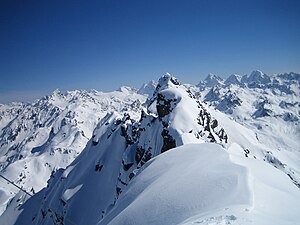
View from the Rotbühelspitze to the Isentällispitz |
||
| height |
2872 m above sea level M. (Switzerland) 2875 m above sea level A. (Austria) |
|
| location |
Graubünden , Switzerland Vorarlberg , Austria |
|
| Mountains | Silvretta , Alps | |
| Dominance | 3.64 km → Schildflue | |
| Notch height | 384 m ↓ Caräirajoch | |
| Coordinates , ( CH ) | 46 ° 54 '48 " N , 9 ° 57' 45" O ( 792234 / 198 895 ) | |
|
|
||
| First ascent | August 8, 1892 by A. Ludwig and Dr. W. Zwicky | |
The Isentällispitz (also Eisenthälispitz or Eisentälispitz ) is 2872 m above sea level. M. high mountain of the Silvretta on the border between Austria and Switzerland . The next town on the Swiss side is Klosters . The state border there also forms the municipal boundary between St. Gallenkirch in the north and Klosters in the south. It is part of the Rotbühlspitz group and is also the highest peak there.
It is not to be confused with a mountain of the same name, also called Gorihorn , 2985 m high north of the Flüelapass , and also not with the Eisentaler peaks in Verwall , at whose northern foot there is an Isatäli = iron valley .
Location of the Isentällispitz in the Silvretta. |
literature
- Günther Flaig, Walther Flaig: Silvretta alpin. Bergverlag Rother, Munich 1996, ISBN 3-7633-1097-5 , pp. 142f.
Web links
- Isentällispitz on hikr.org
Individual evidence
- ↑ Communications of the German and Austrian Alpine Association, Vol. 36, No. 4 (1910), p. 49 ( digitized version ); Note: There, however, 2882 m.
- ↑ a b Digital Swiss National Map https://map.geo.admin.ch
- ↑ Vorarlberg Atlas4. Retrieved November 24, 2019 .
- ↑ Alpenvereinskarte 28/2 "Verwallgruppe Mitte", 3rd edition 2009, ISBN 978 3 928777 36 0


