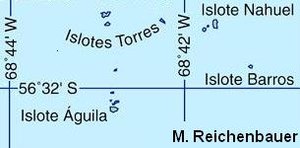
Islote Águila
| Islote Águila | ||
|---|---|---|
| The southernmost part of the Diego Ramírez Islands | ||
| Waters | Drake Street | |
| Archipelago | Diego Ramírez Islands | |
| Geographical location | 56 ° 32 '17 " S , 68 ° 43' 23" W | |
|
|
||
| length | 200 m | |
| width | 250 m | |
| surface | 0.23 ha | |
| Residents | uninhabited | |
Islote Águila (dt. Adlerinselchen ) is the southernmost islet of the Chilean Diego Ramírez Islands south of Cape Horn in the Drake Passage . It belongs to the Región de Magallanes y de la Antártica Chilena , Province Antártica Chilena and the municipality of Cabo de Hornos .
The rock has an area of about 2.3 hectares and belongs to the southern of the two Diego Ramírez groups. It is located 1.3 km south of Isla Gonzalo and 2.3 km south of Isla Bartholomé . the main island of the archipelago. About 100 m to the north there is another, somewhat smaller rock island. On the way to Isla Gonzalo there are other small islands; the northern ones are called Islas Torres . The northernmost of these is about the size of Islote Águila, the remaining five are smaller.
The Diego Ramírez Islands were discovered by Bartolomé García de Nodal in 1619 . As the southernmost of these, Islote Águila was considered the southernmost country on earth for 156 years until James Cook sighted the South Sandwich Islands in 1775 . The Diego Ramírez Islands are very isolated and difficult to reach and are therefore only entered sporadically by the Chilean Navy.
Islote Águila is located about 108 km southwest of Cape Horn on the island of Hornos . The next major landmass is Hermite Island, 89 km to the north-northeast. The nearest island to the south is Smith Island in the southern group of the South Shetland Islands , 789 km to the south-southwest. This already belongs to the Antarctic or the continent of Antarctica .
Therefore, the southernmost point of the island at 56 ° 32 '17 ″ S , 68 ° 43 ′ 19 ″ W is generally considered to be the southernmost country of the Diego Ramírez Islands and thus Chile , South America and the entire supercontinent America . If the archipelago is no longer part of America because of its remote location, this honor goes to the much better known Cape Horn . If you also include the South Sandwich Islands , which are at least 2,640 km from mainland South America, the southernmost point of South America is on Cook Island . However, this definition is unusual.
Individual evidence
- ↑ Map from OpenStreetMap
- ↑ All distances were determined with Google Maps .


