Itaituba
| Itaituba | ||
|---|---|---|
|
Coordinates: 4 ° 17 ′ S , 55 ° 59 ′ W Itaituba on the map of Pará
|
||
| Basic data | ||
| Country | Brazil | |
| State | Pará | |
| City foundation | 1856 | |
| Residents | 97,704 (2011) | |
| City insignia | ||
| Detailed data | ||
| surface | 62,040.947 km² | |
| Population density | 1.57 inhabitants / km 2 | |
| height | 15 m | |
| Time zone | UTC −4 | |
| City Presidency | Valmir Clímaco de Aguiar (PMDB) | |
| Website | ||
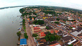
| Aerial view of Itaituba | ||
Itaituba , officially Portuguese Município de Itaituba , is a city in the Brazilian state of Pará . It is located on the Rio Tapajós and had about 98,000 inhabitants in 2011. The area of the municipality is 62,041 km². Itaituba is one of the economic centers in the western part of the state.
economy
Itaituba is the center of an area in which gold is mined along the Rio Tapajós and its tributaries. The gold digger camps (Garimpos) of the Garimpeiros were and still are often supplied with necessary goods and fuel by small aircraft.
Web links
Commons : Itaituba - collection of images, videos and audio files
- City Prefecture website , Prefeitura Municipal (Brazilian Portuguese)
- City Council website , Câmara Municipal (Brazilian Portuguese)
- IBGE : Itaituba - Panorama. In: cidades.ibge.gov.br. Retrieved November 11, 2018 (Brazilian Portuguese). Updated statistics.


