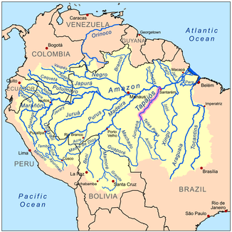
Rio Tapajós
| Rio Tapajós | ||
| Data | ||
| location | Brazil | |
| River system | Amazon | |
| Drain over | Amazon → Atlantic | |
| origin | Confluence of the Rio Juruena and Teles Pires 7 ° 21 ′ 1 ″ S , 58 ° 8 ′ 18 ″ W |
|
| muzzle | at Santarém in the Amazon Coordinates: 2 ° 24 ′ 34 ″ S , 54 ° 42 ′ 56 ″ W 2 ° 24 ′ 34 ″ S , 54 ° 42 ′ 56 ″ W
|
|
| length | 810 km | |
| Right tributaries | Rio Jamanxim | |
| Big cities | Santarém | |
| Medium-sized cities | Jacareacanga , Itaituba | |
| Small towns | Fordlândia (c. 1000 pop.) | |
| Communities | Aveiro | |
| Navigable | above Itaituba only for smaller ships | |
|
The Rio Tapajós several kilometers before it flows into the Amazon. |
||
The Rio Tapajós [ˌχiu ˌtapɐˈʒɔz] is one of the largest tributaries of the Amazon . Originating from the confluence of the Rio Juruena and Teles Pires , it flows into the largest river on earth on the right, southern bank near Santarém .
The largely abandoned settlement of Fordlândia lies on the banks of the Rio Tapajós .
River course
The Rio Tapajós has a length of about 810 kilometers without source rivers. With its right source river, the Teles Pires , it comes to 2,291 kilometers. The river is navigable along its entire length, but above Itaituba only for smaller ships because of the many rapids. Cruise ships from Germany also sail into the lower reaches across the Atlantic and the Amazon.
The Rio Tapajós is characterized by its blue-green color. At the mouth, the river is about twelve kilometers wide and therefore wider (but also flatter) than the Amazon. He has the lower reaches of bright white shore beaches with very fine sand that go very flat into the river. In contrast to the Amazon, its water is very clear.
At Itaituba , almost 400 kilometers from the mouth of the Amazon River, crosses the forest road Transamazônica the Rio Tapajós. At this point, the Transamazônica is closest to the Amazon. From Santarem, a road that is very well developed for local conditions leads parallel to the river to the Transamazônica (Santarem-Cuiaba highway).
In the upper reaches of the river there are rapids that larger ships cannot negotiate. There are plans to blow up the rocks so that large ships can also sail into the source rivers. The reason for this is the raw materials that can be extracted there.
The construction of the Sao Luiz do Tapajós hydropower plant is also planned in a nature conservation-sensitive area, which could ensure a reliable energy supply for the region. On August 4, 2016, the environmental authority IBAMA refused the necessary environmental license, without which the project cannot be built.
The largest tributaries
The largest tributaries include (downstream):
- Río Cururu (right)
- Río Leste (right)
- Río das Tropas (right)
- Río Crepori (right)
- Rio Jamanxim (right)
- Río Igarapé Açu (right)
See also
- Abaré (hospital ship, 2006)
- List of the longest rivers on earth
Web links
- An (English-language) report on the "mega-project" rapid blasting can be found at Tapajos Waterway Project Profile ( Memento from August 4, 2003 in the Internet Archive )
- A scientific report on the condition of the jungle along the right bank area on the lower reaches of the Rio Tapajós is here: Site Scouting and Selection for the Tapajós National Forest and Santarém / Belterra, Pará. ( Memento from May 27, 2002 in the Internet Archive )
- A bike tour on the Transamazonika leads in parts along the Rio Tapajós. The description also contains pictures: www.transamazon.de
Individual evidence
- ↑ Environment Agency prevents Brazil's largest dam. In: Zeit online from August 5, 2016 [accessed August 9, 2016].
- ↑ Danilo Fariello: Ibama nega licença ambiental de Hidrelétrica no rio Tapajós. In: O Globo, August 4, 2016 (Portuguese) [accessed August 9, 2016].
- ^ Kümmerly + Frey Rand McNally : International Atlas . Published by Georg Westermann Verlag, ISBN 3-07-508962-1

