
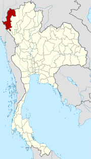
Mae Hong Son (Province)
| Mae Hong Son | |
|---|---|
| แม่ฮ่องสอน | |

|
|
| statistics | |
| Capital: | Mae Hong Son |
| Telephone code: | 053 |
| Surface: |
12,681.2 km² 8. |
| Residents: |
241,847 (2009) 74. |
| Population density : | 19 E / km² 77. |
| ISO 3166-2 : | |
| Governor : | Naruemon Panwat |
| map | |
  |
|
Mae Hong Son ( Thai : แม่ฮ่องสอน ) is a province ( Changwat ) in the northern region of Thailand . The capital of Mae Hong Son Province is also called Mae Hong Son .
geography
The province of Mae Hong Son is embedded in a wild mountain landscape, which is bordered by partially inaccessible jungle. For a long time this led to the isolation of the province and to a certain degree of legal freedom, so that a transshipment point for illegal drugs could be established here. The distance to the capital Bangkok is more than 900 kilometers.
| Adjacent provinces and areas: | |
|---|---|
| north | Land border to Myanmar (Burma) |
| east | Chiang Mai |
| south | Tak |
| west | Land border with Myanmar |
Important cities
Important rivers
- Mae Nam Pai ( Pai River ),
- Mae Nam Ramat (also: Mae Nam Lamat - Ramat River ),
- Mae Nam Yuam ( Yuam River ),
- Mae Nam Salawin ( Saluen , also: Nam Kong ) and the
- Mae Nam Ngao ( Ngao River ).
climate
Climate data according to Thai Meteorological Department:
| Mae Hong Son | ||||||||||||||||||||||||||||||||||||||||||||||||
|---|---|---|---|---|---|---|---|---|---|---|---|---|---|---|---|---|---|---|---|---|---|---|---|---|---|---|---|---|---|---|---|---|---|---|---|---|---|---|---|---|---|---|---|---|---|---|---|---|
| Climate diagram | ||||||||||||||||||||||||||||||||||||||||||||||||
| ||||||||||||||||||||||||||||||||||||||||||||||||
|
Average monthly temperatures and rainfall for Mae Hong Son
|
|||||||||||||||||||||||||||||||||||||||||||||||||||||||||||||||||||||||||||||||||||||||||||||||||||||||||
The climate is consistently a little cooler than in the rest of the country, but still tropical - monsoonal . The mean temperature is 25.5 ° C. The maximum temperature in 2008 was 40.5 ° C, the lowest temperature was measured at 12.0 ° C. On 132 rainy days fell 841.5 mm in the same year .
Economy and Importance
The province is one of the poorest in Thailand. The long seclusion has meant that in addition to smuggling across the border into Myanmar, drug trafficking has also acquired a certain economic importance. Since the Chiang Rai province was controlled more closely, the traders have increasingly moved here.
The increasing development by roads means that tourism increases. Nature lovers come here who love the solitude in the mountains and who go on trekking tours or wild raft trips on the numerous rivers.
In 2000, 75% of Mae Hong Son's population worked in agriculture. The "Gross Provincial Product" ( gross domestic product ) amounted to 8.843 billion Baht in 2011 , which corresponds to 37,456 Baht (approx. 1,220 US dollars) per inhabitant. Mae Hong Son is thus the economically weakest province of the northern region and one of the weakest in Thailand as a whole. The official minimum wage in the province is 227 baht per day (around € 4; as of April 1, 2012).
Data
The table below shows the share of the economic sectors in the gross provincial product in percent:
| Industry | 2006 | 2007 | 2008 | 2009 |
|---|---|---|---|---|
| Agriculture | 34.0 | 31.0 | 35.2 | 34.6 |
| Industry | 10.8 | 13.1 | 11.3 | 11.5 |
| Other | 55.2 | 55.9 | 62.5 | 53.9 |
The industry that contributed most to the province's economic output in 2011 was agriculture with 2.429 billion baht, followed by education with 1.389 billion baht, and administration, defense and compulsory social security with 1.167 billion baht.
Land use
The following land use is documented for the province:
- Forest area: 7,042,311 Rai (11,267.7 km²), 88.9% of the total area
- Agricultural area: 250,398 rai (400.6 km²), 3.2% of the total area
- Unclassified area: 633,078 rai (1,012.9 km²), 8.0% of the total area
Dams
- Pha Bong Dam - dams the Mae Nam Ramat north of the provincial capital
Worth mentioning
When the film Air America (1990) was shot in this area, a "suitable for the needs of filmmakers" hotel was built on the outskirts of Mae Hong Son , which still exists today: the Mae Hong Son Mountain Inn .
traffic
Airports
education
According to the NSO, only 51.7% of 6–24 year olds attended school in 2000.
population
Demographics
In 1990 Mae Hong Son Province had 158,400 residents compared to 210,500 in 2000, an increase of 33%. The province's population is very young: the average age was 25.3 years, and over 30% of the population was under 14 years old. In 2000, about 10.1% of the people lived in urban areas, with the largest proportion living in Mae Hong Son and Khun Yuam.
About 89.2% of the population of Mae Hong Son owned their own home in 2000, 50.9% had their own television, but only 33.4% cooked with gas or electric stoves. The adult residents of Mae Hong Son had attended school an average of only 4.5 years, far less than the national average.
Ethnicities and languages
Most of the population is made up of hill tribes : Karen , Hmong , Lawa , Lahu and Lisu . In the 2000 census, 63% of the population said they spoke languages of the hill tribes, compared with only 51% in 1990. At the same time, the proportion of Buddhists decreased from 83% (1990) to 75% (2000), while the proportion of foreign citizens increased from 0.4% (1990) to 6% (2000).
history
The area was settled since prehistoric times, as can be seen from traces in the numerous cave systems: raw tools, cucumber and betel seeds and other finds indicate a settlement since around 8000 BC. Chr.
During the historical period, ownership often changed between Thailand and Burma. Nevertheless, no major battles took place here and the mountain peoples continued their peaceful life, under whatever rule. Even today there are tensions on the border, which do not originate from the states themselves, but from rioters and political activists.
See also: History of Thailand and corresponding entry in Mae Hong Son
Attractions
Mae Hong Son has a large number of natural beauties, most of which are in national parks:
- National parks and nature reserves:
Symbols
The seal of the province shows an elephant in the water and is a reminder of the enormous economic importance of the animals. The local tree is Millettia brandisiana ( กระพี้ จั่น ), the local flower is the sunflower Helianthus annuus ( บัว ทอง ).
The Mae Hong Son Province motto is:
- "Mae Hong Son, the city of the three mists,
- Doi Kong Mu shrine goes high in the sky
- The forests are thick with evergreen trees
- Peoples of good nature and beautiful customs,
- And the famous Bua Tong flowers attract us all. "
Administrative units
Provincial Administration
The province consists of seven districts ( Amphoe ) , which are further subdivided into 45 municipalities ( Tambon ) and 402 villages ( Muban ) .
|

Local administration
A provincial administrative organization ( บริหาร ส่วน จังหวัด , อบ จ for short , Ongkan Borihan suan Changwat ; English Provincial Administrative Organization , PAO) exists for the entire area of the province .
There is one town ( เทศบาล เมือง - Thesaban Mueang ) in the province : Mae Hong Son ( เทศบาล เมือง แม่ฮ่องสอน ) and 4 small towns ( เทศบาล ตำบล - Thesaban Tambon ).
Individual evidence
- ↑ a b c d e f NSO: Key indicators of the population and households (English)
- ↑ a b Thailand in Figures (2012), p. 269.
- ↑ "Industry" includes: Mining and quarrying; Manufacturing; Electricity, gas and water supply; Construction
- ^ "Others" include: Wholesale and retail trade; Hotels and restaurants; Transport, storage and communication; Real estate; Education; Health and social work, ...
- ^ Gross Provincial Product at Current Market Prices: Northern Provinces, National Economic and Social Development Board, 2011.
- ↑ Department of Provincial Administration : As of 2012 (in Thai)
literature
- Thailand in Figures, Vol.II: Region and Province . 16th edition 2012-2013, Alpha Research Co., Ltd., Nonthaburi, Thailand 2012, ISBN 978-616-7256-12-6
Web links
- Provincial Administration website (in Thai)
- German information from the Tourist Authority of Thailand (TAT) [last accessed on December 4, 2013]
- Overview map of the province (names in English and Thai) [last accessed on December 4, 2013]
North : Chiang Mai | Chiang Rai | Kamphaeng Phet | Lampang | Lamphun | Mae Hong Son | Nakhon Sawan | Nan | Phayao | Phetchabun | Phichit | Phitsanulok | Phrae | Sukhothai | Tak | Uthai Thani | Uttaradit
Northeast : Amnat Charoen | Bueng Kan | Buri Ram | Chaiyaphum | Kalasin | Khon Kaen | Loei | Maha Sarakham | Mukdahan | Nakhon Phanom | Nakhon Ratchasima | Nong Bua Lam Phu | Nong Khai | Roi Et | Sakon Nakhon | Si Sa Ket | Surin | Ubon Ratchathani | Udon Thani | Yasothon
Central : Ang Thong | Ayutthaya | Bangkok | Chachoengsao | Chai Nat | Chanthaburi | Chon Buri | Kanchanaburi | Lop Buri | Nakhon Nayok | Nakhon Pathom | Nonthaburi | Pathum Thani | Phetchaburi | Prachin Buri | Prachuap Khiri Khan | Ratchaburi | Rayong | Sa Kaeo | Samut Prakan | Samut Sakhon | Samut Songkhram | Saraburi | Sing Buri | Suphan Buri | Stepped
South : Chumphon | Krabi | Nakhon Si Thammarat | Narathiwat | Pattani | Phang-nga | Phatthalung | Phuket | Ranong | Satun | Songkhla | Surat Thani | Trang | Yala
Coordinates: 19 ° 17 ' N , 97 ° 58' E