Jachsu
|
Jachsu Яхсу, Mutschnakion |
||
|
|
||
| Data | ||
| location | Tajikistan | |
| River system | Amu Darya | |
| Drain over | Kyzylsu → Pandsch → Amu Darya → Aral Sea (temporarily) | |
| source | in the Chasratischoch Mountains 38 ° 32 ′ 36 ″ N , 70 ° 29 ′ 20 ″ E |
|
| muzzle |
Kyzylsu coordinates: 37 ° 46 ′ 29 " N , 69 ° 34 ′ 1" E 37 ° 46 ′ 29 " N , 69 ° 34 ′ 1" E
|
|
| length | 160 km | |
| Catchment area | 2710 km² | |
| Outflow location: 16 km above the mouth |
MQ |
29.2 m³ / s |
| Medium-sized cities | Kulob | |
|
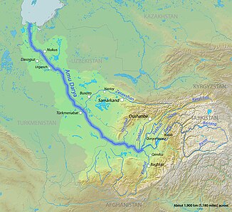
Course of the Jachsu (English Yakhsu) and the lower reaches of the Kysylsu in the catchment area of the Amu Darya |
||
The Jachsu ( Russian Яхсу ; in the upper reaches Mutschnakion ) is a left tributary of the Kysylsu in Tajikistan in the catchment area of the Punj .
The Jachsu rises in the Chasratischoch Mountains . It flows first in a westerly and later in a south-westerly direction through the Pamir Mountains . In the lower reaches it flows through the city of Kulob . The Jachsu has a length of 160 km and drains an area of 2710 km². The jachsu is mainly fed by the snowmelt . It has floods between March and May , with the highest discharge values in May. The mean discharge 16 km above the mouth is 29.2 m³ / s. The river is ice-covered between December and February. The water of the Jachsu is used for irrigation .
