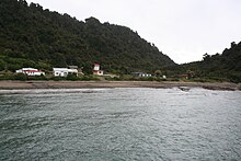
Jackson Bay (bay)
Coordinates: 43 ° 58 ′ S , 168 ° 41 ′ E
The Jackson Bay (also Jackson's Bay) is a gently curved, about 24 km wide bay in Westland District in the region West Coast on the South Island of New Zealand .
The bay on the Tasman Sea is bounded on the land side by the Southern Alps .
Naming
The Jackson Bay was called Open Bay by Captain Cook , the origin of the current name can no longer be clearly determined. Possible namesake or sources of names are:
- Port Jackson , New South Wales (Australia), from there many settlers who settled here started their crossing over the Tasman Sea;
- James Hayter Jackson, a locally known whaler;
- William Jackson, also a whaler who was part of a group of offenders who were abandoned here in 1810.
geography
The westernmost point of the bay is the Jackson Head headland , the northeast boundary is not precisely defined, but the common alluvial cone of the Turnbull River and the Okuru River can be considered the outermost point. The small archipelago of the Open Bay Islands is located at this point about five kilometers from the coast in the Tasman Sea.
The bay marks a major change in the terrain of the west coast. To the north, the small fertile plains between the mountains and the sea allow cattle to be raised to a moderate extent. To the south, the plains near the coast disappear and the land becomes steeper and significantly more mountainous. Within 60 kilometers, the country is shaped by the first deep glacial valleys on Lake McKerrow ; further south, these glacial valleys form the fjords of the Fiordland National Park .
The bay marks the southernmost stretch of the road network along the West Coast. The narrow road winds on the coast from Haast to the northeastern end point of the small fishing village of Jackson Bay near Jackson Head.
The road to Jackson Bay is often cited as one of the best kept secrets from tourists on the West Coast.
The village is near the mouth of the Arawhata (or Arawata) River ; the third river that brings its water from the mountains into the Tasman Sea in this short stretch of coast is the Waiatoto River, which flows 10 kilometers east of Jackson Head .
history
Settlement of the area around 1810 is mentioned for the first time in various records. At first, emigrants from England attempted agriculture and cattle breeding in the region south of Haast. Between 1875 and 1878, around 400 people settled in the Jackson Bay area. The fight against the jungle and the very rainy nature was not very successful for the Italian, around 100 German and some Polish settlers. Around 1880, the majority of the residents moved to the Otago region . Today less than a hundred people live permanently along the coast; only because of the increasing yacht and boat traffic along the coast, for which Jackson Bay is the last stop before the fjords in Fiordland National Park and the torn coastline, more people occasionally come by.
literature
- AWReed, The Reed Dictionary of New Zealand Place Names, Reed Books, Auckland, 2002, ISBN 0-7900-0761-4
Web links
- Map showing the location of the Jackson Bay settlement on the bay of the same name
- Lake Moeraki, Haast, Okuru Beach . Tourism West Coast Inc., archived from the original onMarch 31, 2007; accessed on August 24, 2014(English, original website no longer available).
- Background to a pre-colonial song, mentioning the suspension of offenders on the West Coast of New Zealand

