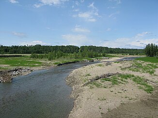
James River (Red Deer River)
| James River | ||
| Data | ||
| location | Alberta (Canada) | |
| River system | Nelson River | |
| Drain over | Red Deer River → South Saskatchewan River → Saskatchewan River → Nelson River → Hudson Bay | |
| origin | James Lake, on the eastern edge of the Canadian Rockies, 51 ° 43 ′ 55 ″ N , 115 ° 25 ′ 49 ″ W |
|
| Source height | 1673 m | |
| muzzle |
Red Deer River Coordinates: 51 ° 54'31 " N , 114 ° 34'1" W 51 ° 54'31 " N , 114 ° 34'1" W. |
|
| Mouth height | 1027 m | |
| Height difference | 646 m | |
| Bottom slope | approx. 6.8 ‰ | |
| length | approx. 95 km | |
| Catchment area | approx. 850 km² | |
| Discharge A Eo : 821 km² Location: 11 km above the mouth |
MQ 1966/2015 Mq 1966/2015 |
4.4 m³ / s 5.4 l / (s km²) |
The James River is an approximately 95 km long left tributary of the Red Deer River in the western Canadian province of Alberta .
River course
The James River rises on the eastern edge of the Canadian Rocky Mountains . The 1673 m high mountain lake James Lake forms the source of the river. The James River flows in a predominantly east-northeast direction through the foothills of the Rocky Mountains. After almost 50 km he reaches the Great Plains . Alberta Highway 22 crosses the river 9 km above the mouth . This finally flows into the Red Deer River 13 km north-northeast of Sundre . The James River forms numerous river loops along its course .
Hydrology
The James River drains an area of about 850 km². The mean discharge 11 km above the mouth is 4.4 m³ / s. June is the month with the highest discharge with an average of 13.3 m³ / s.
