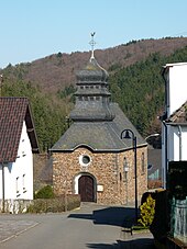
Jammelshofen
|
Jammelshofen
Local community Kaltenborn
Coordinates: 50 ° 23 ′ 28 " N , 7 ° 1 ′ 45" E
|
||
|---|---|---|
| Height : | 525 (500–600) m above sea level NHN | |
| Incorporation : | November 7, 1970 | |
| Postal code : | 53520 | |
| Area code : | 02691 | |
|
Location of Jammelshofen in Rhineland-Palatinate |
||
|
Jammelshofen
|
||
Jammelshofen is part of the Kaltenborn community in the Ahrweiler district in Rhineland-Palatinate .
Jammelshofen is a few kilometers SSE from the main town of Kaltenborn. Due to the distance, the landscape is characterized by the typical hilly landscape of the Eifel , as in Kaltenborn . The village is right at the foot of the Hohe Acht . The Herschbach , which is considered to be the source of the Kesselinger Bach , also rises here .
Jammelshofen was an independent municipality until it was incorporated into Kaltenborn on November 7, 1970.
Individual evidence
- ↑ Official municipality directory 2006 ( Memento from December 22, 2017 in the Internet Archive ) (= State Statistical Office Rhineland-Palatinate [Hrsg.]: Statistical volumes . Volume 393 ). Bad Ems March 2006, p. 181 (PDF; 2.6 MB). Info: An up-to-date directory ( 2016 ) is available, but in the section "Territorial changes - Territorial administrative reform" it does not give any population figures.


