
Jampea
| Jampea | ||
|---|---|---|
| Waters | Lake Flores , Lake Banda | |
| Archipelago | Salajar Islands | |
| Geographical location | 7 ° 5 ′ S , 120 ° 42 ′ E | |
|
||
| surface | 162.85 km² | |
| Highest elevation | 521 m | |
| Residents | 14,186 (2010) 87 inhabitants / km² |
|

Jampea (also Tanah Jampea , Tanahjampea , Djampea ) is the second largest of the Indonesian Salajar Islands .
Surname
The island name is supposedly derived from the Makassar word jappo for "rotten", which is derived from the bad reputation of the wood from here. One reason why the tree population was traditionally not used in the shipyards of the nearby islands.
geography
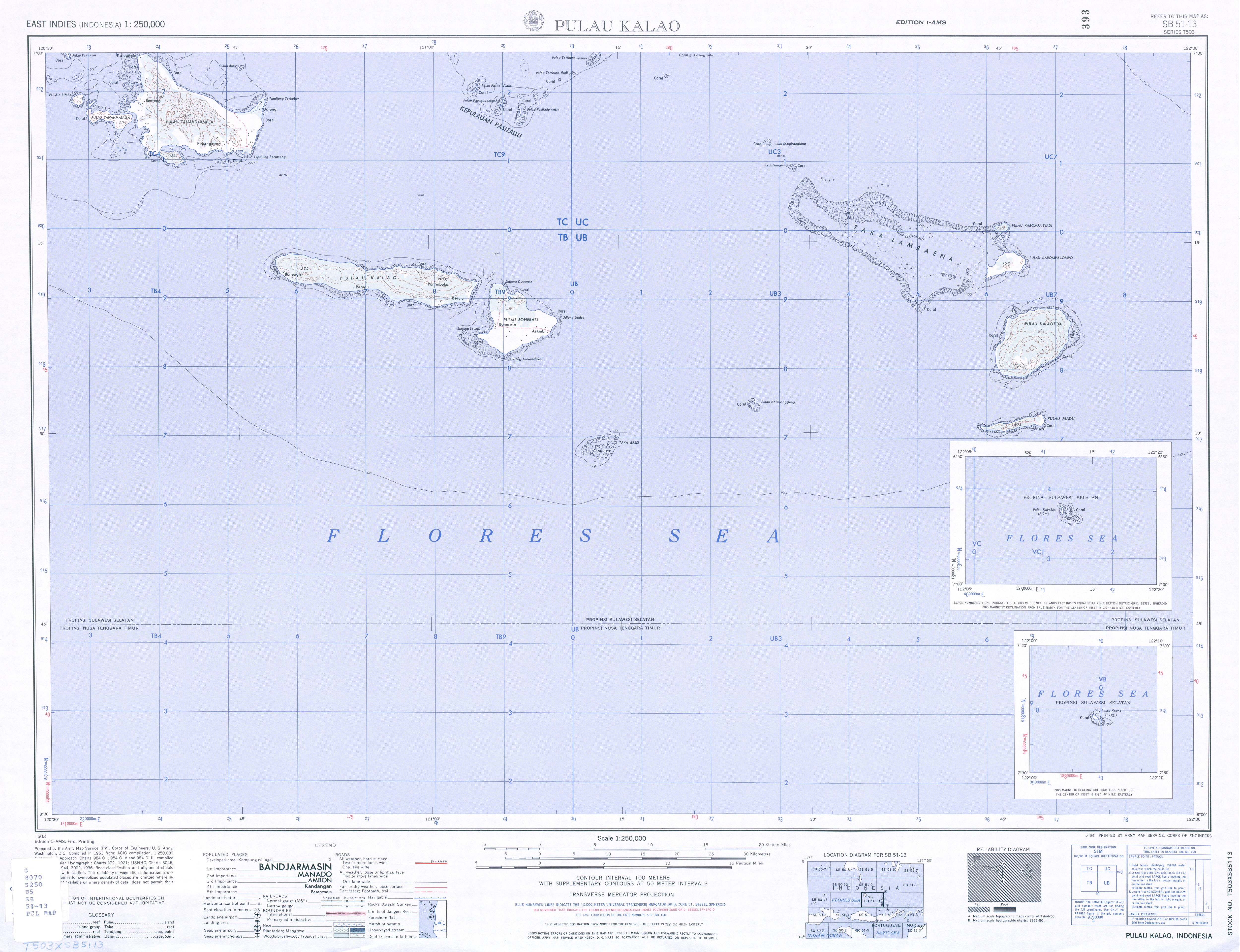
Jampea is located along with the other Salajar Islands south of Sulawesi . To the west is the Floressee , to the east the Banda Sea . The Salajar Islands form an arc with Jampea in the center in the southwest. The main island of Salajar is to the north. Off the coast of Jampea to the west, including the islands of Tanamalala (Tanahmalalla) and Bimba, are located . To the north is the island of Batu . There are also other offshore islands. Direct larger neighbors are Kajuwadi in the north and Lalao (Lambego) in the east, a little further east to Pasi Tallu , Pasi Tallu Laut and Pasi Tallu Raja .
Jampea is part of the governmental district ( Indonesian Kabupaten ) Salajar Islands of the province of South Sulawesi ( Indonesian Sulawesi Selatan ). The western part forms the district ( Indonesian Kecamatan ) Pasimendunggu with the administrative villages ( Indonesian Desa ) Mnahmke in the north (908, 2010 census), Bontosaile in the northeast (735 inhabitants), Kembang Ragi in the northern center (2301 inhabitants), Labuang Pamajang in the south Center (1069 inhabitants) and Maminasa (1866 inhabitants). The offshore islands also belong to the district, summarized as the village of Tanamalala (766 inhabitants). The eastern part of the island of Jampea forms the district Ostpasimendunggu ( Indonesian Pasimendunggu Timur ) with the administrative villages Bonobaru in the northwest (2202 inhabitants), Bontobulaeng in the northeast (2781 inhabitants), Lembang Baji in the southwest (971 inhabitants) and Bontomalling in the southeast (1353 inhabitants) . Both districts together have a total area of 162.85 km², the highest point above the sea is 521 m . The island is of volcanic origin. The island is about 20 kilometers long and 10 kilometers wide.
Climate and vegetation
The annual rainfall reaches 1253 mm per year. The rainy season lasts from late December to February, but showers can still often occur in March and April. The rest of the year is mostly dry, but it can still rain sometimes.
On the offshore island of Tanamalala there are large numbers of trees and on Jampea there were around 10,000 hectares of primary forest until 1947 .
fauna
.jpg)

There are two endemic species of snakes on Jampea. To the rolling snakes belonging Cylindrophis Isolepis and the bamboo viper belonging Trimeresurus fasciatus . From the reticulated python a dwarf subspecies occurs here Python reticulatus jampeanus . Males are a maximum of 2.10 meters long, females a maximum of 3.35 meters, otherwise lengths of four or six meters are normal.
Among the birds, the Everett monarch ( Monarcha everetti ) and the yellow-cheeked cockatoo ( Cacatua sulphurea ) stand out. The cockatoo could possibly be an independent subspecies, C. s. djampeana . Other representatives of the Jampea bird life are the Djampea rainbow lorikeet ( Trichoglossus haematodus djampeanus ), white- nest salangans ( Aerodramus fuciphagus fuciphagus ), macklot mistletoe ( Dicaeum maugei ) and pink-headed fruit pigeon ( Ducula rosacea ).
Often are pigs. They live relatively undisturbed as the local Muslims do not hunt them. Only Chinese traders, who sometimes come from Makassar , hunt here because of the meat. It is possible that they too introduced the pigs here. Often there is a mane deer ( Cervus timorensis ) and cynomolgus monkey ( Macaca fascicularis ).
A butterfly that is otherwise only found on Kalao is the braid butterfly ( Cethosia biblis atia ).
Residents
A total of 14,186 people live on Jampea without the offshore islands of Tanamalala. The population is largely Muslim, with traditional beliefs being incorporated into Islam. Traditional language is Makassar .
economy
Mainly maize is planted. Other crops include cassava, sweet potatoes, bananas and beans. Peas and peanuts are exported to Makassar, as is copra . Up to two harvests per year are possible. The wet rice cultivation in horizontal fields ( sawah ) is also worth mentioning . However, this only allows an annual harvest. Water buffalo, goats, chickens, ducks, horses, dogs and cats are kept. Coastal residents fish or trade in the region.
history
Ships were built on Jampea from the 17th to 19th centuries.
Web links
Individual evidence
- ^ A b c d Victor T. King: Environmental Challenges in South-East Asia , 2013 , accessed November 19, 2016.
- ^ Map of the southern Salajar Islands , accessed November 19, 2016.
- ↑ a b c d e f g Harald Beyer Broch: Cultural Variation on the Islands in the Sea of Flores 1981 , accessed on November 19, 2016.
- ^ Map of Pasimassunggu , accessed on November 19, 2016.
- ↑ Map of Ostpasimassunggu , accessed on 19 November 2016th
- ↑ a b Penduduk Indonesia menurut desa 2010 ( Memento from March 27, 2014 in the Internet Archive ) (Indonesian; PDF; 6.0 MB), accessed on January 26, 2013.
- ^ Map of the Salajar Islands , accessed November 19, 2016.
- ^ Birdlife International: Pulau Tana Jampea , accessed November 19, 2016.
- ^ Tony Whitten, Greg S. Henderson, Muslim Mustafa: Ecology of Sulawesi , 2012 , accessed November 19, 2016.
- ^ Auliya, M., P. Mausfeld, A. Schmitz, W. Böhme: Review of the reticulated python (Python reticulatus Schneider, 1801) with the description of new subspecies from Indonesia. Natural Sciences Volume 89, Issue 5; 2002: p. 202