Jaworzyński Przysłop
| Jaworzyński Przysłop | ||
|---|---|---|
|
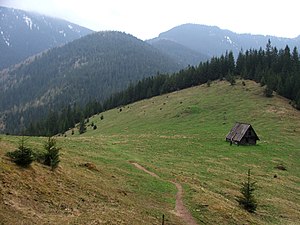
View from the Polana Jamy mountain pasture |
||
| height | 1269 m npm | |
| location | Poland | |
| Mountains | Western Tatras , Carpathian Mountains | |
| Coordinates | 49 ° 15 '42 " N , 19 ° 49' 33" E | |
|
|
||
The Jaworzyński Przysłop is a mountain in the Polish West Tatras with a height of 1269 meters. It is located in the municipality of Kościelisko .
Location and surroundings
The Jaworzyński Przysłop is located in the Polish Tatras between the Dolina Długa and Głębowiec valleys , two side valleys of the main Dolina Chochołowska valley .
tourism
There are no marked hiking trails leading to the summit. However, the summit is clearly visible from the surrounding valleys.
The Ornak Hut and Chochołowska Hut are ideal starting points for climbing the hiking trails around the summit .
Web links
Commons : Jaworzyński Przysłop - collection of images, videos and audio files
supporting documents
- Zofia Radwańska-Paryska, Witold Henryk Paryski, Wielka encyklopedia tatrzańska, Poronin, Wyd. Górskie, 2004, ISBN 83-7104-009-1 .
- Tatry Wysokie słowackie i polskie. Mapa turystyczna 1: 25.000, Warszawa, 2005/06, Polkart, ISBN 83-87873-26-8 .

View from the Polana Jamy mountain pasture , the summit on the right

