
Jukkokutōge funicular
| Jukkokutōge funicular | |||||||||||||||||||||
|---|---|---|---|---|---|---|---|---|---|---|---|---|---|---|---|---|---|---|---|---|---|
 View of the valley station
| |||||||||||||||||||||
| Route length: | 0.316 km | ||||||||||||||||||||
| Gauge : | 1435 mm ( standard gauge ) | ||||||||||||||||||||
| Maximum slope : | 408 ‰ | ||||||||||||||||||||
| Height difference: | 101 m | ||||||||||||||||||||
| Society: | Izuhakone Tetsudō | ||||||||||||||||||||
|
|||||||||||||||||||||
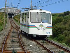
The Jukkokutōge funicular ( Japanese 十 国 峠 ケ ー ブ ル カ ー , Jukkokutōge Kēburukā ; Engl. Jukkokutōge Cable Car ) is a funicular in Japan . It is located on the territory of the municipality Kannami in Shizuoka Prefecture . It is operated by the Izuhakone Tetsudō railway company , a company of the Seibu Group .
description
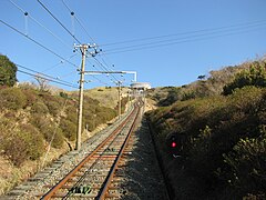
The valley station is next to a rest area on the main road from Atami to Hakone . From there the train leads straight up to the 766 m high Jukkoku-tōge ("Ten Country Pass"). This pass - actually a mountain ridge at the transition between the southern flank of the Hakone volcano and the Izu Peninsula - is so named because areas in ten historical provinces can be seen from there, including Mount Fuji , Suruga Bay and the Miura Peninsula and the Tokyo Skytree . The single-track route with a siding is 316 m long and overcomes a height difference of 101 m, the maximum incline is 408 ‰. The train is in operation daily from 8:50 a.m. to 4:50 p.m., with the two cars (each with a capacity of 96 people) usually running every ten minutes; a trip takes three minutes.
history
The funicular was opened on October 16, 1956 by the Sunzu Tetsudō railway company (renamed Izuhakone Tetsudō in 1957). The drive system and the cars came from the Myōken funicular in Kawanishi ( Hyōgo Prefecture ). This had been opened in 1925, but had to be shut down in 1944 so that the rails could be used in war-important locations. Until it was rebuilt in 1960, the Jukkokutōge funicular railway was the only one in Japan with a standard gauge of 1435 mm for almost four years ; the cape gauge (1067 mm) is common.

View from above
Car in the turnout
View to the mountain station

Valley station

Mountain station


Web links
- Jukkokutōge Funicular Website (Japanese)
Individual evidence
- ↑ 運 賃 ・ 営 業 時間 な ど. Izuhakone Tetsudō , 2018, accessed November 12, 2018 (Japanese).
Coordinates: 35 ° 7 ′ 39.8 ″ N , 139 ° 2 ′ 21.5 ″ E