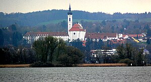
Jungfernberg (Dießen am Ammersee)
| Jungfernberg | ||
|---|---|---|
|
View from Ammersee, Jungfernberg to the left of the steeple |
||
| height | 694 m above sea level NHN | |
| location | Bavaria , Germany | |
| Coordinates | 47 ° 56 '32 " N , 11 ° 3' 19" E | |
|
|
||
| Age of the rock | Worm Ice Age | |
| particularities | Significant headwaters | |
The Jungfernberg is a 694 m high moraine hill from the Würme Ice Age in the area of the market in Dießen am Ammersee in the Upper Bavarian district of Landsberg am Lech .
Location and surroundings
The Jungfernberg is located about one kilometer west of the Wengen district of the market in Dießen am Ammersee.
The hamlet of Bischofsried lies on the eastern slope of the mountain, while the Bayerdießen forest extends to the southwest .
history
In 1682 the elevation is first referred to as Jungfrauenberg , presumably the Canonissenstift St. Stephan owned there.
Headwaters
On the eastern slope of the Jungfernberg, water is pumped near Bischofsried. The spring discharge is between 120 and 135 l / s, the delivery rate 59 l / s to 1,000,000 m³ / year.
Two elevated tanks with 2000 cubic meters in Dießen and 800 cubic meters in Pitzeshofen are filled with the water. The source supplies the town of Dießen am Ammersee.
The Beurerbach also rises on the northern slope of the Jungfernberg .
Individual evidence
- ^ Geology Atlas Bavaria. Accessed January 31, 2019 .
- ^ BayernAtlas. Accessed January 30, 2019 .
- ↑ M. Aquinata Schnurer OP: Home book of the market in Dießen am Ammersee . Ed .: Markt Dießen am Ammersee. Jos. C. Huber KG, Dießen am Ammersee 1976, p. 25 .
- ↑ Markt Diessen am Ammersee - technical data. Accessed January 31, 2019 .
- ↑ Stephanie Millonig: Which water flows where? Accessed January 31, 2019 .


