Jungtal
| Jungtal | ||
|---|---|---|
|
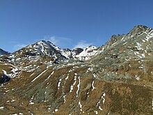
The rear Jungtal, in the background from the left Rothorn ( 3278 m ), Jungpass ( 2990 m ), Furggwanghorn ( 3162 m ) and Wyssegga ( 3168 m ). |
||
| location | Canton of Valais | |
| Waters | Jungbach | |
| Mountains | Valais Alps | |
| Geographical location | 626 123 / 115944 | |
| Topo map | National map of Switzerland 1: 25,000 (LK25), sheet 1308, St. Niklaus | |
|
|
||
| Type | U valley | |
| height | 2339.4 to 3343 m above sea level M. | |
| length | 4 km | |
| use | Winter and summer tourism, alpine farming , hydropower | |
The Jungtal is a high valley in the Valais Alps above St. Niklaus Dorf . The high valley is framed by two and three thousand meter peaks and opens up on the northeast side towards the Mattertal . It can be reached on foot via the Junge and Jungtalweg - Alpenblumenweg . The Jungtal is a worthwhile excursion destination both in summer and in winter.
geography
The Jungtal extends from the stables of Alp Jungtal, which are located at 2387 m , over 4 kilometers in a south-westerly direction to the Brändjihorn at an altitude of 3308 m . From the lowest point at 2339.4 m , the Jungtal rises to 3343 m to the highest point above the valley, the Wasuhorn , which can be found east of the Brändjihorn. The Jungbach , fed by the Junggletscher , runs through the high valley and plunges 1,272 meters above the steeply sloping left rock face of the Mattertal north of St. Niklaus Dorf into the Mattervispa at the end of the Jungtal .
The Jungtaljoch ( 3220 m ), which lies north of the Brändjihorn and above the Junggletscher, and the Jungpass ( 2990 m ), which can be found north of the Rothorn ( 3278 m ), which in turn is north of the Jungtaljoch, connect the rear Jungtal with the rear Turtmann valley .
Jungtalalp
The Jungtalalp or its alpine hut and stables, which are located at the entrance of the Jungtal at an altitude of 2387 m , as well as their pastures are used in high summer in the month of August.
Weisshornweg
The Weisshornweg runs along the left flank of the Jungtal and leads northeast from the Wasuhorn over the Wasulicke at 3114 m into the Wasmutälli.
«Wasserleite» ( Suonen ) and hikes
| «Water pipe» | description | Connection height | Final height | length | Difficulty of the hike | additional |
|---|---|---|---|---|---|---|
| «Wasserleita» Obra | The «Wasserleita» Obra extends from the Jungtal out of the valley in a north-east direction to Junge and feeds the small lake at the Seewjinen rest area at 1998 m above sea level. M. , which is not far above the terminus of the St. Niklaus Dorf - Jungs passenger cable car . At this resting place there are also fire places and wooden tables with benches. In addition, the water from the «Wasserleita» Obra is used for agriculture. | 2358 m , left side of the Jungbach | 1960 m | 1.8 km | The hiking trail along the «Wasserleita» is partly marked and has a level of difficulty T2. | |
| «Wasserleita» Sparruwasser | The «Wasserleita» Sparruwasser stretches from the Jungbach in a south-easterly direction to Sparren and is fully irrigated for agricultural use. | 2275 m , right side of the Jungbach | 1860 m | 1.8 km | The hiking trail along the «Wasserleita» is partly unmarked and has the difficulty T3. |


