Käpfle
| Käpfle | ||
|---|---|---|
|
Käpfle and Wasenwald |
||
| height | 594.6 m above sea level NHN | |
| location | Baden-Wuerttemberg , Germany | |
| Mountains | Swabian Alb | |
| Coordinates | 48 ° 27 '31 " N , 9 ° 8' 56" E | |
|
|
||
| particularities | Lookout tower, former location of a castle | |
The Käpfle is 594.6 m above sea level. NHN high mountain north of the Reutlingen district of Bronnweiler in Baden-Württemberg .
history
Until 1073 there was a castle on the Käpfle, from which the name “Alteburg” of the estate and the restaurant to the north of the Käpfles go back. However, there are not even remnants of the wall left of the castle itself.
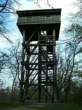
Since 1974 there has been a twelve-meter-high wooden observation tower on the Käpfle , which is open all year round. From 2017 the tower was closed for repairs. Individual pieces of wood, the viewing platform and the roof shingles have been renewed. The railings were adapted to the current requirements. The tower has been open again since the beginning of April 2019.
Web links
Commons : Käpfle observation tower - collection of images
Individual evidence
- ↑ Map services of the Federal Agency for Nature Conservation ( information )
- ↑ Lookout tower on Käpfle reopened - Reutlingen - Reutlinger General-Anzeiger. Retrieved April 17, 2019 .


