Kaʻū desert
The Ka'ū Desert is on the southwest side of the Kīlauea located -Kraters desert in the district of Ka'u , the southernmost district on the Big Iceland from Hawaii . It mainly consists of dried lava residues, volcanic ash, sand and gravel. The desert covers an area of about 100 square kilometers of the Kīlauea volcano along the southwestern rift zone. The area is devoid of vegetation, which is mainly due to the acid rains.
climate
The climate of the Kaʻū Desert is characterized by strong solar radiation, annual temperatures between 14.8 and 18.1 ° C with an average of 16.4 ° C and an annual rainfall of more than 1,000 millimeters. The resulting tropical climate would normally not lead to the formation of a desert, but a tropical rainforest. However, several factors favor desertification instead .
The first factor is soil composition, as the soil is made up of lava flows, layers of volcanic ash and tephra, all of which have an adverse effect on the development of plants. The second factor is water shortage due to the high porosity of the soil and the lack of a moisture-retaining plant cover . The third and most serious factor is acid rain throughout the year due to the sulfur dioxide- containing gases that rise from the volcanic vent of Halemaʻumaʻu and drift off to the southwest due to the trade winds . These rains, which can reach a pH value of up to 3.4 during an outbreak , inhibit plant growth , especially since the soil is acidic due to the seeping rain.
Landforms
- Mauna Iki - volcanic cone formed in 1919 on the slope of Kīlauea at about 912 m above sea level
- Puʻukoaʻe - mountain peaks in the desert plateau
- Kamakaiʻa Hills - chain of several ejection craters on the western slope of Kilauea
- Pu'u Kou - hill made of Pāhoehoe lava
- Yellow Cone - mountain peak
Location and access
The Kaʻū Desert is located in Kaʻū Administrative District, the southernmost district of Hawaii County. It is located on the south-western flank of the Kīlauea, along the south-west trench, below the summit of the volcano, which is defined by the caldera at 1246 m above sea level. The exact border of the desert cannot be precisely defined as it gradually changes into green vegetation.
The Kaʻū desert is suitable for walks and hikes during volcanically inactive times. It can be reached by following Highway 11 from Kona to the volcano counterclockwise. The starting point is on Crater Rim Drive. When crossing the desert, one can traverse the Great Rift and the Southwest Rift Zone, a large fracture zone that looks like a giant ridge in the earth, before reaching the Kīlauea volcano.
The area is part of the Hawaii Volcanoes National Park . However, it is often closed in times of high volcanic activity, as the trade winds blow from Halemaʻumaʻu to the southwest and can then contain poisonous gases.
The 1790 eruption
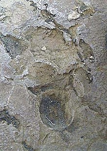
One of the most devastating eruptions with a magnitude of VEI -4 in Hawaiian history occurred in 1790. The Keanakakoi eruption released volcanic ash which, due to the action of electrostatic forces and moisture, formed tephra balls that rained down as lapilli in the desert. Chief Keōua Kuahuʻula was returning from a battle against the dominant Chief Kamehameha I in this area. At least 80 of his Hawaiian warriors suffocated when volcanic ash entered their lungs. According to historical sources, the 3-phase eruption claimed more than 400 lives. According to legend, footprints preserved in the ashes come from these warriors. However, recent research suggests that this area has been entered and used by humans for hundreds of years.
See also
Web links
Individual evidence
- ^ Peter Schiffman et al .: Acid-fog deposition at Kilauea volcano: A possible mechanism for the formation of siliceous-sulfate rock coatings on Mars . In: Geological Society of America (Ed.): Geology . 34, No. 11, November 2006, pp. 921-924. doi : 10.1130 / G22620A.1 .
- ↑ https://www.lpi.usra.edu/meetings/lpsc2000/pdf/1649.pdf
- ↑ https://bigislandnow.com/2016/09/30/kamakaia-hills-what-are-they-and-why-are-they-there/
- ↑ http://luirig.altervista.org/pics/index4.php?search=Hawaii+Volcanoes+National+Park.+Puu+Kou,+a+prehistoric+cone+o...&page=1
- ↑ Closed Areas and Advisories on Hawaii Volcanoes National Park web site
Coordinates: 19 ° 24 '31 " N , 155 ° 17' 48" W.


