
Kabanjahe
| Kabanjahe | |
|---|---|
| Basic data | |
| State : | Indonesia |
| Province : | North Sumatra |
| Coordinates : | 3 ° 8 ' N , 98 ° 27' E |
| Residents : | 63,326 (2010) |

| |
Kebanjahe on the map of Indonesia |

Kabanjahe (translated: Ginger City) is a city in the province of North Sumatra of the Indonesian island of Sumatra and the seat of government of the Karo district . The city is located north of Lake Toba , 12 km south of Berastagi and northwest of the independent city (Kota) Pematang Siantar and southwest of the provincial capital Medan .
population
The city and its surroundings are settlement areas of the Karo Batak , one of several Batak people groups (such as the Angkola, Mandailing, Toba, Pakpak and Simalungun Batak). Today the Chinese , Achinese , ethnic Malay , Minangkabau and resettled Javanese also live here . The population is predominantly Roman Catholic and a minority Muslim . A first census (1990) showed 46,000 inhabitants in the city, whereupon over 60,000 were forecast for 2011. In 2010 the population was then determined to be 63,326.
Trading location
Kabanjahe is located in the culturally interesting Batak area. The Batak markets, for example, sell Ulos . The Monday market, which is used for a lively exchange of information, is important.
tourism
Kabanjahe is often chosen as a starting point for visiting the Karo-Batak, especially for trips to Barusjahe or Lingga . Barusjahe is often flown to with microlight aircraft. In Lingga alone there are about 30 traditional Batak houses, of which about a dozen are longhouses . A culinary specialty of the region is the pork dish Babi pangang .

About 24 km away from the city, the Sipisopiso waterfall falls in a narrow track from a height of 120 m into Lake Toba. The 2,454 m high Gunung Sinabung , which erupted for the first time in 400 years in August 2010, and Lake Kawar can also be easily reached from Kabanjahe. Another volcano, the 2095 m high Gunung Sibayak , is located northwest of Berastagi and has sulfur-containing springs. The sulfur is broken down by the residents of the area as it is used as a medicine and as a pesticide .
Education
In 1986 the Universitas Karo Area (UKA) was founded in the city.
traffic
The cities of Kabanjahe and Berastagi are well connected. A city-to-city trip takes about 90 minutes.
Individual evidence
- ↑ 2010 Census ( Memento of the original from February 7, 2015 in the Internet Archive ) Info: The archive link was inserted automatically and has not yet been checked. Please check the original and archive link according to the instructions and then remove this notice. (Pages 239–240; PDF; 5.9 MB)
- ↑ Archived copy ( Memento of the original dated December 29, 2011 in the Internet Archive ) Info: The archive link was automatically inserted and not yet checked. Please check the original and archive link according to the instructions and then remove this notice.
- ↑ Joshua Eliot, Jane Bickersteth, Sumatra Handbook
- ^ Rita Smith Kipp, Dissociated Identities: Ethnicity, Religion, and Class in an Indonesian Society
literature
- Wilhelm Volz, Royal Prussian Academy of Sciences in Berlin, Volume 1: Die Batakländer. Humboldt Foundation, D. Reimer (E. Vohsen), 1909
- Wolfgang Clauss, Economic and social change among the Simalungun Batak of North Sumatra, Breitenbach, 1982 - 265 pages, ISBN 3-8815-6230-3
- Tribus Vol. 55-57, Stuttgart (Germany). Museum for regional and ethnology, Society for Earth and Ethnology eV, Stuttgart, Stuttgart (Germany). Linden Museum for Ethnology, 2006, Linden Museum Stuttgart
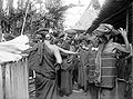
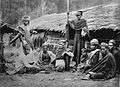
Historical images of the Karo Batak
Dancing Karo Batak women with earrings called padung padung

Group picture of Karo Batak pounding rice
A group of Karo Batak
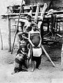
Plaid women
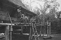
On the doorstep

Skull house
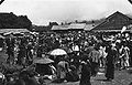
Market in Berastagi

Fishing on Laut Kawar


_en_duiventil_TMnr_60045307.jpg)

