Lake Toba
| Lake Toba | ||
|---|---|---|
|
||
| Lake Toba | ||
| Geographical location | Sumatra | |
| Drain | Asahan → Strait of Malacca | |
| Islands | Samosir , Pardapur | |
| Places on the shore | Parapat | |
| Location close to the shore | Medan | |
| Data | ||
| Coordinates | 2 ° 37 ' N , 98 ° 49' E | |
|
|
||
| Altitude above sea level | 904 m | |
| surface | 1 103 km² | |
| length | 87 km | |
| width | 27 km | |
| volume | 240 km³ | |
| scope | 294 km | |
| Maximum depth | 505 m | |
|
particularities |
||
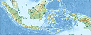
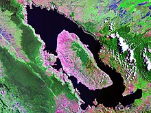
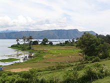
The Lake Toba ( Indonesian Danau Toba ) is a 87 km long and 27 km wide lake in the north of the Indonesian island of Sumatra in the province of Sumatra Utara . With a total area of 1776.5 km² (for comparison: Lake Constance 536 km²), including the 647 km² Samosir peninsula , it is the largest lake in Indonesia and the largest crater lake on earth.
The basin of Lake Toba was created by the eruption of the Toba super volcano 73,880 ± 320 cal BP years ago. According to the Toba catastrophe theory , this is said to have led to a worldwide cooling, which may have decisively impaired the spread of humans in the sense of a genetic bottleneck .
geography
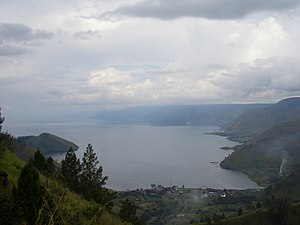
Lake Toba is located in a volcanic-tectonic basin, 77 km south of the provincial capital Medan . The level of the lake is 905 meters above sea level. The shore length is 294 km. The dormant volcanoes Dolok Pusukbukit (in the west) and Dolok Tandukbenua (in the northwest) border Lake Toba .
Lake Toba is drained by the 150 km long Asahan River, in the extreme southeast from the Bay of Porsea. Downstream, the Asahan breaks through the eastern fringes of the Basin in a gorge up to 300 m deep. As a result of this deep erosion , the level of the lake has dropped by around 250 m.
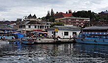
Parapat on the east bank is the largest and most important town on the lake. Other cities in the vicinity of the lake that are important for infrastructure are Berastagi in the northeast, Pematang Siantar in the east and Sibolga on the Indian Ocean .
geology
The Barisan Mountains , which run lengthways through Sumatra, are plate-tectonic folding, created by the pressure of the Indo-Oceanic plate advancing from the southwest. According to the Dutch geologist Reinout Willem van Bemmelen , this process between the Pliocene and the Pleistocene resulted in a dome-shaped bulge up to 2000 m high in and around Lake Toba, which he named "Batak tumor". The extent of this bulge goes far beyond that of today's lake: the length along the longitudinal axis of Sumatra is 275 km, the width up to 150 km.
During the bulging, larger and deeper expansion cracks gradually developed until about 74,000 years ago the gas-rich magma of the batholith, which was only a little deeper, found its way out in a gigantic eruption through these cracks .
Toba volcano
eruption
It is believed that the Toba eruption was the largest volcanic eruption in the past two million years. Volcanic ash from the eruption can be found throughout the Indian Ocean and much of India . Besides the Oruanui eruption of the Taupo in New Zealand 26,500 years ago and the Lava Creek eruption of the Yellowstone in the USA, it was the only eruption that achieved a volcanic explosiveness index (VEI) of 8 during this period . It is estimated that 2800 km³ of volcanic material (including 800 km³ of ash) were hurled up to 80 km and dispersed in the atmosphere .
Cooling off the world climate
The eruption of the super volcano was followed by a cooling of the global climate, a so-called volcanic winter . Estimates speak of a 3 to 5 K cooling. Model calculations showed that, depending on the selection of the input values for the model, the cooling lasted for several decades and at the beginning of this cold period the cooling could even have been 8 to 17 K. The outbreak could therefore have caused the coldest years of the Worm Ice Age.
Toba disaster theory
In 1993, Ann Gibbons pointed to the temporal connection between the eruption and the less precise dating of a genetic bottleneck in the evolution of Homo sapiens . Comparative analysis of mitochondrial DNA suggests that the population has been reduced to 1,000 to 10,000 individuals.
The Neanderthals living in Europe and Asia to Siberia and Homo erectus living in Asia as well as Homo floresiensis living much closer to the eruption site survived this natural disaster and only died out much later. In southeast India, stone tools of the same kind were found both below and above the tuff layer , suggesting a continuity of hominine settlement in this region.
Fish fauna
Since the lake is poor in nutrients , the fish fauna of the lake is relatively poor in species. The only endemic species are the rasbora tobana (it is also found in rivers that flow into the lake) and Neolissochilus thienemanni . Other fish species in the lake are Panchax , pfeifferae Nemacheilus , Homaloptera gymnogaster , Channa Gachua , cross-striped snakehead , walking catfish , silver bar , Schwanefelds bar , Pearl Danio , Osteochilus vittatus , spot cash , Rasbora jacobsoni , Tor tambra , peaceful betta , Betta taeniata and East Asian swamp eel . To those established by the human species are climbing fish , Mozambique tilapia , Oreochromis niloticus , grass carp , carp , giant gourami , snakeskin gourami , Spotted gourami , guppy and swordtail .
Web links
- Data on Lake Toba at LakeNET on worldlakes.org (English)
- Supervolcano Toba at naturgewalten.de
- Data Toba eruption on a server of the Oregon State University (English)
- Poster: Toba Magma System ( Memento from July 5, 2010 in the Internet Archive ). (PDF; 1.1 MB; English)
Individual evidence
- ↑ a b Haryatiningsih Moedjodo, Payaman Simanjuntak, Peter Hehanussa, Lufiandi: Lake Toba. (PDF; 614 kB) Experience and Lessons Learned Brief. (No longer available online.) In: projects.inweh.unu.edu. United Nations University , archived from the original on July 23, 2016 ; accessed on March 30, 2013 (English).
- ↑ Michael Storey et al .: Astronomically calibrated 40Ar / 39Ar age for the Toba supereruption and global synchronization of late Quaternary records. In: PNAS . Volume 109, No. 46, 2012, pp. 18684–18688, doi: 10.1073 / pnas.1208178109 .
- ^ Managing Lakes and their Basins for Sustainable Use. A Report for Lake Basin Managers and Stakeholders ( July 23, 2011 memento in the Internet Archive ). (PDF; 5.2 MB), International Lake Environment Committee Foundation, Kusatsu, Japan 2005, accessed on March 30, 2013.
- ↑ Michael Balter: Of two minds about Toba's impact. In: Science . Volume 327, No. 5970, 2010, pp. 1187–1188, doi: 10.1126 / science.327.5970.1187-a .
- ↑ George Weber: Toba Volcano. (No longer available online.) Andaman Association, archived from the original on June 30, 2007 ; Retrieved December 25, 2009 .
- ^ Alan Robock et al .: Did the Toba volcanic eruption of ∼74 ka BP produce widespread glaciation? In: Journal of Geophysical Research: Atmospheres. 114, 2009, ISSN 0148-0227 , doi: 10.1029 / 2008JD011652 (free full text).
- ↑ Michael S. Rampino, Stephen Self: Bottleneck in human evolution and the Toba eruption. In: Science . 262, 1993, doi: 10.1126 / science.8266085 (free full text).
- ↑ Michael Petraglia et al .: Middle Paleolithic Assemblages from the Indian Subcontinent Before and After the Toba Super-Eruption. In: Science . Volume 317, 2007, pp. 114-116, doi: 10.1126 / science.1141564 .
- ↑ Daniel N. Lumbantobing: Four New Species of the Rasbora trifasciata Group (Teleostei: Cyprinidae) from Northwestern Sumatra, Indonesia. In: Copeia . 4, pp. 644-670, doi: 10.11646 / zootaxa.3764.1.1 .
- ↑ Bungaran Saragih and Satyawan Sunito: Lake Toba: Need for an integrated management system. In: Lakes & Reservoirs: Research & Management. Volume 6, No. 3, 2001, pp. 247-251, doi: 10.1046 / j.1440-1770.2001.00155.x .
- ↑ a b Species in Toba. In: FishBase . 2012. Retrieved March 13, 2018.
