Kaikoura Ranges
| Kaikoura Ranges | ||
|---|---|---|
|
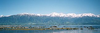
View from the Kaikoura Peninsula to the Seaward Kaikoura Range |
||
| Highest peak | Tapuae-o-Uenuku ( 2885 m ) | |
| location | South Island ( New Zealand ) | |
|
|
||
| Coordinates | 42 ° 0 ′ S , 173 ° 40 ′ E | |
The Kaikoura Ranges are two mountain ranges in the northeast of the South Island of New Zealand , which can be seen as the northernmost extension of the Southern Alps with two parallel main ridges along the Alpine fault in a southwest-northeast direction . Both mountain ranges are between 80 and 90 km long, merge into other mountain ranges in the southwest near Hanmer Forest Park , while in the northeast they taper to sea level in the direction of Cape Campbell .
Between the Inland Kaikoura Range and the Seaward Kaikoura Range runs the border between the regions of Marlborough and Canterbury .
Called by Captain James Cook Looker-on Mountains ("Highly Visible Mountains"), they got their name from the Kaikoura Peninsula and the town of Kaikoura .
Seaward Kaikoura Range
The Seaward Kaikoura Range (sea-side Kaikoura mountain range) runs partially parallel to the coastline to the Pacific and is best viewed from the sea or from the Kaikoura Peninsula. The highest mountain in the mountain range is the Manakau with 2608 m . The mountains appear very imposing, especially in summer, due to the extreme contrasts between the extremely warm weather on the coast and the snow-capped mountains in the mountains.
The New Zealand State Highway 1 and the railway line of the Tranz Scenic from Picton to Christchurch meander between the coast and the mountain range, offering very beautiful perspectives during the train journey.
Inland Kaikoura Range
The Inland Kaikoura Ranges gives evidence to the Seaward Kaikoura Range, some more prominent peaks in the mountain range and has the 2,885 meter high Tapuae-o-Uenuku , with the poetic translation of the Maori language "impression of the Rainbow", also the highest mountain of the two mountain ranges.
The Clarence River , which flows into the Pacific at Clarence Bridge, runs between the two ridge lines .


