
Hanmer Springs
| Hanmer Springs | ||
| Geographical location | ||
|
||
| Coordinates | 42 ° 31 ′ S , 172 ° 50 ′ E | |
| Region ISO | NZ-CAN | |
| Country |
|
|
| region | Canterbury | |
| District | Hurunui District | |
| Ward | Hanmer Springs Ward | |
| Residents | 840 (2013) | |
| height | 370 m | |
| Post Code | 7334 | |
| Telephone code | +64 (0) 3 | |
| website | hanmersprings.co.nz | |
| Photography of the place | ||
 Queen Mary Hospital around 1950 |
||

Hanmer Springs is a place and well-known thermal bath in the Hurunui District of the Canterbury region on the South Island of New Zealand .
geography
The place is located 28 km north of Culverden and around 72 km southwest of Kaikoura , on the southern foothills of the Hanmer Range, which is up to 1875 m high . The Hanmer Plain , located south of the village, borders the Hanmer River and the Waiau River .
history
In 1859, the farmer William Jones from Culverden found springs on the edge of the mountains from which tepid and almost boiling water gushed. In 1860 the area was secured by the Provincial Government of Nelson Province and designated for the creation of a thermal bath. To gain access to the inaccessible area, the Waiau Ferry Bridge was built in 1864 and in 1883 the Government Lands Department created baths and protected areas on a two- acre area around the springs. In 1893 a pipe was placed over the hottest spring so that visitors could inhale the rising vapors.
Four years later, the government created the Queen Mary Hospital, a facility that could be used as a sanatorium. With the beginning of World War I , the hospital was rededicated and now served as the South Island Military Hospital for the care and recovery of wounded from the war. Later, in the 1960s, it was used as a rehabilitation center for alcohol and drug addicts and closed in 2003.
In 2005 the hospital and its surrounding area were listed as a historical monument.
population
In the 2013 census, the town had 840 inhabitants, 14.8% more than in the 2006 census.
Infrastructure
Road traffic
Hanmer Springs is on the New Zealand State Highway 7A km south east-west direction with about 8 running New Zealand State Highway 7 , respectively.
Air traffic
Hanmer Springs Airport is three kilometers south of the town and has a grass runway that connects the town with other cities in the country.
tourism
Hanmer Springs is a popular tourist destination all year round. In the warm months the area is ideal for hiking, in the cold winter months in the thermal baths or in the two ski areas for winter sports. Sightseeing flights start regularly from Hanmer Springs , where you can see the alpine surroundings of the place from the air.
The village is also the starting point for a detour to Molesworth Station , Lake Tennyson or Rainbow Station . Off-road vehicle tours or guided group tours also take you along the gravel roads through the Rainbow Valley and Nelson Lakes National Park , as well as towards Picton , Blenheim and the Marlborough region in summer .
See also
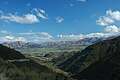
View from Jacks Pass

Waiau Ferry Bridge over the Waiau River near Hanmer Springs

View from Jollies Pass towards Hanmer Springs

Hanmer Springs Hot Pools


Web links
Individual evidence
- ↑ a b 2013 Census QuickStats about a place: Hanmer Springs . Statistics New Zealand , accessed June 7, 2017 .
- ↑ a b Topo250 maps . Land Information New Zealand , accessed June 7, 2017 .
- ^ A b Queen Mary Hospital (Former) . Heritage New Zealand , accessed June 7, 2017 .
- ↑ a b Hanmer Springs History . Hanmer Springs Thermal Pools , accessed June 7, 2017 .
- ^ Queen Mary Hospital Historic Reserve . Hurunui District Council , accessed June 7, 2017 .
- ↑ Shane Cundy: Hanmer Springs in summer and autumn . 100% Pure New Zealand. Retrieved November 26, 2015.