Kamo (river)
|
Kamo Kamogawa |
||
|
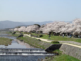
Cherry blossoms on the Kamo |
||
| Data | ||
| location | Japan | |
| River system | Yodo | |
| Drain over | Katsura → Yodo → Seto Inland Sea | |
| source |
Sajikigatake MOUNTAINS 35 ° 9 '42 " N , 135 ° 43' 18" O |
|
| muzzle | in Fushimi-ku , Kyōto in the Katsura coordinates: 34 ° 55 '53 " N , 135 ° 44' 14" E 34 ° 55 '53 " N , 135 ° 44' 14" E
|
|
| Big cities | Kyoto | |
The Kamo ( Japanese 鴨 川 or 賀茂川 Kamogawa ) is a river that flows through Kyōto . It is 31 kilometers long and a tributary of the Yodo .
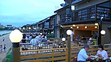
Coming from Mount Sajikigatake north of Kyoto, it flows through the city center and connects with the Katsura at Fushimi . The river bank is a walking path for local residents and tourists. In summer, restaurants open outdoor spaces with views of the river.
There are paths all over Kyoto that can be used to walk along the river. Although the water level is usually relatively low - well below a meter in most places - low-lying areas are sometimes flooded during the rainy season.
Demachiyanagi ( 出 町 柳 ) in north Kyoto, where the Kamo flows into the Takano ( 高 野 川 Takano-gawa ), is a place for summer barbecues.
Source and history
The source of the Kamo is in the Sajikigatake Mountains in northern Kyoto. After flowing through the mountain village of Kumogahata , it enters the Kyoto Basin near Kamigamo in the Kita district . After flowing from south to south-east between the Kamigamo and Shimogamo shrines , the Takano joins the Kamo at the Kamo Bridge on Imadegawa Street. Then it flows south through the municipality of Nakagyō . At the Shijo Bridge on the edge of the well-known Gion district , it turns south-west until it flows into the Katsura at Kamitoba in the southern district of Fushimi. In the municipality of Nakagyō, the Takase ( 高 瀬 川 Takase-gawa ) branches off to the west and runs parallel to the south.
About the name
Officially, the river is written using the Kanji for 'wild duck' 鴨 ( kamo ) and 'river' 川 ( gawa ). North of Imadegawa Street, where he meets Takano, however, a different spelling is common, with the same pronunciation: 賀茂川 or less often 加 茂 川 . This is probably due to its proximity to the Kamigamo shrine ( 上 賀 茂 神社 Kamigamo-jinja , German for 'upper Kamo shrine' ). From the Deai to the Iwaya Bridge in northern Kyoto, it is called Kumogahata-gawa ( 雲 ヶ 畑 川 ) because the river flows through Kumogahata. Finally, north of the Iwaya Bridge to its source, it is known as Ojitanigawa ( 祖父 谷川 ).
history
It used to be the eastern boundary of the old Japanese capital Heian-kyō and had an important meaning according to Fengshui . Since the flow of the river is very straight forward, many believe that it is of artificial origin. However, there are no records of such a project.
The old capital was often threatened by flooding. Emperor Shirakawa commented:
"Although I am the ruler of Japan, there are three things that are beyond my control: the rapids of the Kamo River, the fall of the dice in the game, and the monks in the mountains."
The merchant Suminokura Ryōi had the Takase built parallel to the Kamo in the early 17th century. From then on, transports ran over this channel instead of the unstable main stream. The river is connected to Lake Biwa by means of the Biwa Canal .
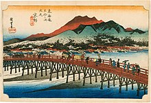
The meeting between Minamoto no Yoshitsune and Musashibō Benkei on the Gojō Bridge over the river is a well-known story of the late Heian period . The Sanjō Bridge was considered to be the western end of the Tōkaidō during the Edo period .
In the past, the clear river water was an important source of drinking water for the people of Kyoto. It also played an important role in Kyoyuzen dyeing, a well-known craft of Kyoto.


