Cape of the Three Peaks
| Cape of the Three Peaks | ||
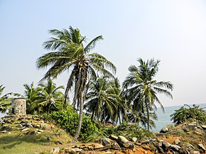
 Cape of the Three Peaks and ruins of the old lighthouse from 1875 |
||
| Geographical location | ||
|
|
||
| Coordinates | 4 ° 45 ′ N , 2 ° 5 ′ W | |
| location | Southern tip of Ghana | |
| Waters | Atlantic Ocean | |
The Cape Three Points (engl. Cape Three Points ) is in the present Ghana and forms the southernmost point of the country (4 ° 30 'north of the equator ). It was discovered by Portuguese sailors and is located between Akwidaa and Prince's Town. The name comes from the Portuguese Cabo de Tres Puntas .
By 1700 the Cape was one of the most settled areas on the Gold Coast . The most famous was the Brandenburg-Prussian "colony" Groß Friedrichsburg , which was founded in 1683. The fortress is now a World Heritage Site . Neighbors were on the one hand the Dutch with branches in Axim , Butry ( Fort Batensteyn ) and Sekondi and on the other hand the English and British possessions of Dixcove .
Web links
Commons : Cape of the three peaks - collection of pictures, videos and audio files
