Karaikal (district)
| Karaikal District காரைக்கால் மாவட்டம் |
|
|---|---|

|
|
| Union Territory | Pondicherry |
| Administrative headquarters : | Karaikal |
| Area : | 157 km² |
| Residents : | 200,222 (2011) |
| Population density : | 1,275 inhabitants / km² |
| Website : | karaikal.gov.in |
The district Karaikal ( Tamil : காரைக்கால் மாவட்டம் ) is a district of the Indian Union Territory of Puducherry (Pondicherry). It includes the eponymous city of Karaikal and some surrounding areas. The Karaikal district has an area of 157 square kilometers and around 200,000 inhabitants (2011 census).
geography
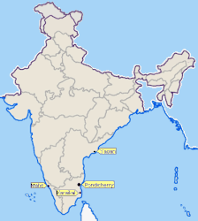
The district of Karaikal is next to Puducherry , Mahe and Yanam one of four spatially separated districts of the Union territory of Puducherry. This emerged from the former French colonial possessions , which fell to India in 1954.
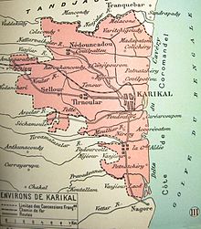
The Karaikal district is located on the Coromandel Coast on the Bay of Bengal in the Kaveri estuary and forms an enclave in the area of the state of Tamil Nadu . It borders the Nagapattinam district to the north and south and the Tiruvarur district to the west . The Karaikal district has an area of 157 square kilometers and includes the city of Karaikal and some villages in the hinterland. The fertile alluvial land is traversed by seven branches of the mouth of the Kaveri (namely Nandalar, Nattar, Arasalar, Tirumalarajanar, Mudikondanar, Vanijar and Nular).
In the Karaikal district there is an alternately humid tropical climate . The annual mean temperature in Karaikal is 28.4 ° C, the annual mean precipitation is 1,278 mm. Most of the rainfall occurs during the northeast monsoon between October and December. It also rains during the southwest monsoons in August and September.
population
According to the 2011 Indian census, the Karaikal district has a population of 200,222. It is the second largest of the four districts of the Union Territory of Puducherry and is home to around one sixth of its inhabitants. The district is very urban: 49 percent of the population live in urban areas. The population density is correspondingly high with 1,275 inhabitants per square kilometer. 18 percent of the district's population are scheduled castes . The literacy rate is 87 percent.
According to the 2011 census , Hindus make up the majority of the inhabitants of the Puducherry district with 76 percent. There are also larger minorities of Muslims (14 percent) and Christians (9 percent). As in neighboring Tamil Nadu, the main language is Tamil , which, according to the 2001 census, is spoken by 98 percent of the district's population as their mother tongue. Around one percent speaks Telugu , the rest other languages.
Attractions
The Kaveri Delta, to which the Karaikal district belongs, is a region rich in culture and history with a high density of important Hindu temples . With the Shiva temples of Thiruvettakudy , Kovilpathu , Dharmapuram and Tirunallar, four of the 274 holy places of Tamil Shaivism ( Padal Petra Sthalams ) are located in the area of the district . The temple of Tirunallar also houses a shrine for the god Shani ( Saturn ). He belongs to the Navagraha Temple , a group of nine temples that are dedicated to the Hindu planetary deities . Thanks to the extremely popular Shani shrine, the temple of Tirunallar is a place of pilgrimage of national importance. Karaikal City also houses a temple dedicated to the poet saint Karaikal Ammaiyar , who was born here in the 6th century.
places
In the district of Karaikal there is a city with its own city government ( Municipality ), a census town ( census town ) and 28 villages. The number of inhabitants is given according to the 2011 census.
- Municipality
- Karaikal (86,838)
- Census city
- Thirumalairayanpattinam (11,264)
- Villages
|
|
Individual evidence
- ↑ a b Census of India 2011: Primary Census Abstract - Puducherry.
- ↑ Climate data from climate-data.org .
- ^ Census of India 2011: C-1 Population By Religious Community. Pondicherry.
- ↑ Census of India 2001: C-16: Population by Mother Tongue (Pondicherry), accessed under Tabulations Plan of Census Year - 2001 .
- ↑ Census of India 2011: Primary Census Abstract Data Tables: Karaikal.
Web links
Coordinates: 10 ° 53 ' N , 79 ° 50' E


