Puducherry (District)
| Puducherry District புதுச்சேரி மாவட்டம் |
|
|---|---|

|
|
| Union Territory | Pondicherry |
| Administrative headquarters : | Pondicherry |
| Area : | 294 km² |
| Residents : | 950,289 (2011) |
| Population density : | 3,232 inhabitants / km² |
The district of Puducherry ( Tamil : புதுச்சேரி மாவட்டம் ; formerly Pondicherry, French Pondichéry ) is a district of the Indian Union Territory of Puducherry . It includes the eponymous capital Puducherry and some surrounding areas. The Puducherry district has an area of 294 square kilometers and around 950,000 inhabitants (2011 census).
geography
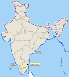
The district of Puducherry is next to Karaikal , Mahe and Yanam one of four spatially separated districts of the union territory of Puducherry. This emerged from the former French colonial possessions , which fell to India in 1954.
The district of Puducherry is located on the Coromandel Coast on the Bay of Bengal 135 kilometers south of Chennai (Madras) and forms an enclave in the area of the state of Tamil Nadu . The district has an area of 294 square kilometers and includes the city of Puducherry with some suburbs and villages in the hinterland. The demarcation between Puducherry and Tamil Nadu (districts Viluppuram and Cuddalore ) is extremely complex: The district consists of twelve fragmented exclaves and in turn includes an enclave belonging to Tamil Nadu .
The district of Puducherry is traversed by the periodically water-bearing Gingee River . South of Puducherry City, it divides into the two estuary arms Ariankuppam and Chunnambar and flows into the Bay of Bengal. In the south, the Penniar River forms the border with the state of Tamil Nadu in places.
population
According to the 2011 Indian census, the Puducherry district has 950,289 inhabitants. It is by far the largest of the four districts of the Union Territory and is home to over three quarters of its residents. The district of Puducherry is largely urban: 69 percent of the population live in urban areas. The population density is correspondingly high with 3,232 inhabitants per square kilometer. Sixteen percent of the district's residents are lower castes ( Scheduled Castes ). The literacy rate is 85 percent.
According to the 2011 census , Hindus make up the vast majority of the inhabitants of the Puducherry district with 90 percent. There are also minorities of Christians (6 percent) and Muslims (3.5 percent). As in neighboring Tamil Nadu, the main language is Tamil , which according to the 2001 census is spoken by 94 percent of the district's population as their mother tongue. Around 2.5 percent speak Telugu , the rest speak other languages.
places
In the district of Pondicherry there are two cities with its own city government ( Municipalities ), three census towns ( census town ), one after the Panchayat managed system village ( Gram Panchayat ) and 62 villages. The number of inhabitants is given according to the 2011 census.
- Municipalities
- Ozhukarai (300,104)
- Pondicherry (244,377)
- Censorship cities
- Ariankuppam (29,808)
- Manavely (15,666)
- Villianur (34,383)
- Grief Panchayat
- Kurumbapet (32,871)
- Villages
Individual evidence
- ↑ a b Census of India 2011: Primary Census Abstract - Puducherry.
- ^ Census of India 2011: C-1 Population By Religious Community. Pondicherry.
- ↑ Census of India 2001: C-16: Population by Mother Tongue (Pondicherry), accessed under Tabulations Plan of Census Year - 2001 .
- ^ Census of India 2011: Primary Census Abstract Data Tables: Puducherry.
Web links
Coordinates: 11 ° 55 ' N , 79 ° 49' E


