Kareedouw
| Kareedouw | ||
|---|---|---|
|
|
||
| Coordinates | 33 ° 57 ′ S , 24 ° 17 ′ E | |
| Basic data | ||
| Country | South Africa | |
| Eastern Cape | ||
| District | Sarah Baartman | |
| ISO 3166-2 | ZA-EC | |
| local community | Kou kamma | |
| height | 300 m | |
| Residents | 4985 (2011) | |
| founding | 1905 | |
|
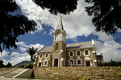
Dutch Reformed Church in Kareedouw
|
||
Kareedouw is a small town with 4,985 inhabitants (as of 2011) in the municipality of Kou-Kamma , Sarah Baartman District , Eastern Cape Province in South Africa . The city is located at an altitude of 300 meters between the Tsitsikamma National Park and the Baviaanskloof Mega-Reserve on Route 62 , 48 kilometers from Humansdorp and 42 kilometers from Joubertina . The city is the seat of the municipal administration.
The city was founded in 1905 as a parish of the Dutch Reformed Church in South Africa . It is named after a tree with the name Karee ( Rhus lancea , English willow vinegar tree). What is meant here is the dew ( Dutch : douw ) on this tree. In the Langkloof Valley, clouds and fog often move in from the sea, which then condense as dew on the trees.
Forestry, orchards and, to a lesser extent, tourism are economically important for the city.
Attractions
- Tsitsikamma National Park
- Baviaanskloof mega-reserve
- Formosa Nature Reserve with 50,000 hectares
Web links
Individual evidence
- ↑ 2011 census , accessed November 22, 2013

