Joubertina
| Joubertina | ||
|---|---|---|
|
|
||
| Coordinates | 33 ° 49 ′ S , 23 ° 51 ′ E | |
| Basic data | ||
| Country | South Africa | |
| Eastern Cape | ||
| District | Sarah Baartman | |
| ISO 3166-2 | ZA-EC | |
| local community | Kou kamma | |
| height | 576 m | |
| Residents | 5752 (2011) | |
| founding | 1907 | |
|
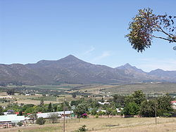
Joubertina with Peak Formosa
|
||
Joubertina is a place in the South African province of Eastern Cape . It is located in the municipality of Kou-Kamma in the district of Sarah Baartman .
geography
Joubertina has 5,752 inhabitants (as of 2011). The place is located on the Wabooms River in the elongated, east-west running valley Langkloof . The distance to the Tsitsikamma National Park on the Indian Ocean is around 30 kilometers. In between are the Tsitsikamma Mountains with the 1,675 meter high Formosa Peak. The Kouga Mountains stretch north of Joubertina .
history
The place was founded in 1907 and named after WA Joubert, a pastor of the Dutch Reformed Church in Uniondale to the west .
Economy and Transport
Fruit growing, especially apples, is the main livelihood. There is also tourism.
Joubertina is located on the regional road " Route 62 " between Oudtshoorn and Humansdorp, which is marketed for tourism . To the west of the village is a small airfield ( ICAO code FAJP). Joubertina located on the Avontuur Railway , the longest narrow gauge line in the world with 610 mm gauge , which is rarely busy.
Attractions
Every year in August the Bloeiselfest (" Blossom Festival") takes place, with which the apple blossom is celebrated.
Web links
- Portrait at route62.co.za (English)
- Portrait at sa-venues.com (English)
Individual evidence
- ↑ 2011 census , accessed on September 21, 2013

