
Karlsfelder Strasse (Munich)
| Karlsfelder Strasse | |
|---|---|
|
|
|
| Basic data | |
| State capital | Munich |
| Borough | Allach-Untermenzing , Feldmoching-Hasenbergl |
| Name received | 1947 |
| Connecting roads |
Dachauer Strasse (west) , Pflaumstrasse (east) |
| Cross streets | Grashofstrasse, Am Gottesackerweg, Schwarzhölzstrasse, Göttnerstrasse, Sommerweide, Ferchenbachstrasse, Kaiserhölzlstrasse, Bundesautobahn 99 (overpass), Achatstrasse, Kristallstrasse, Berthold-Litzmann-Strasse, Dachauer Strasse |
| Numbering system | Orientation numbering |
| Buildings | Feldmoching cemetery , Feldmochinger See , MAN test site |
| use | |
| User groups | Pedestrian traffic , bicycle traffic , individual traffic , public transport |
| Technical specifications | |
| Street length | 3.9 km |
The Karlsfelder road is about 3.9 km road in the north of Munich by Ludwig Field after Feldmoching leads. As a side road from Dachauer Straße in the west, it leads past the truck test site of the MAN company and continues as a local connecting road over the federal motorway 99 , on the north bank of Lake Feldmoching, to the Feldmoching district. There it leads past the Feldmoching cemetery to Grashofstraße in the east, where shortly before Feldmochinger Straße it changes over Pflaumstraße into Lerchenstraße . It crosses the Schwabenbächl , the Würmhölzlgraben (an outflow of the Feldmochinger See) and the Feldmochinger Mühlbach .
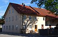
The architectural monuments Karlsfelder Strasse 1a / b and the bridge over the Schwabenbächl are located on it. At Karlsfelder Straße 4 there is a listed wayside cross (mounted wooden crucifix with a weather jacket from the 19th century).
It is named after the northwestern municipality of Karlsfeld .

Karlsfelder Strasse 1
Karlsfelder Strasse 8

Wayside cross at Karlsfelder Straße 4

Bridge over the Schwabenbächl

MAN plant

Feldmochinger Friedhof

Feldmochinger See


See also
Coordinates: 48 ° 13 ′ 1.1 ″ N , 11 ° 30 ′ 41.7 ″ E