
Branodunum Castle
| Brancaster Castle | |
|---|---|
| Alternative name |
a) Branodunum , b) Branoduno |
| limes | Britain |
| section | Litus saxonicum |
| Dating (occupancy) | 3rd to 5th century AD |
| Type |
a) Cohort or cavalry fort, b) Fleet fort? |
| unit |
a) Cohors I Aquitanorum ? b) Equites Dalmatarum Branodunensium , c) Classis Britannica ? |
| size | approx. 2.56 ha |
| Construction |
a) wood-earth? b) Stone construction |
| State of preservation | Square complex with rounded corners, remains of the wall above ground not visible, the heavily eroded, artificially raised fort platform is still recognizable |
| place | Brancaster |
| Geographical location | 52 ° 58 '33.5 " N , 0 ° 39' 2.8" E |
| Subsequently | Caister-on-Sea Fort (southeast) |
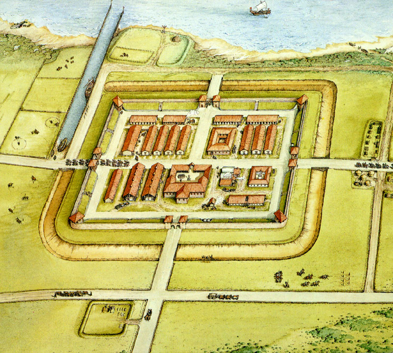
| Reconstruction of the fort |
|---|
| St. Edmundsbury: The Iron Age and the Roman Empire 700 BC to 410 AD |
|
Link to the picture |

The Saxon Coast Fort around 400 AD

Findings sketch 1849–1953

Aerial view of the fort area


_aerial_2018_(2)_(geograph_5773222).jpg)
Branodunum was a Roman fort on the British " Saxon Coast " near the present-day community of Brancaster , County Norfolk , England .
Location and name
The site is east of the present-day town of Brancaster on the A149, eleven kilometers east of Hunstanton and is under the protection of the National Trust . The site is freely accessible to visitors and can be reached via the Norfolk Coastal Walk. In ancient times, the fort stood near the north coast of Brancaster Bay on the eastern bank of the Wash . At that time the sea reached right up to the north wall and the fortress thus also had a protected natural harbor. However, since ancient times the coastline has changed drastically. The former harbor basin is now silted up. Only a slight elevation in the landscape, the heavily weathered, artificially raised platform on which the fortifications stood, can still be seen from the fort today. The remains of the vicus and harbor were almost completely destroyed during the construction of residential buildings in the 1970s. In ancient times there were probably road connections to Holme (west) and Kempstone (south).
The name of the fort is derived from the Celtic and means "fortress of Bran ".
Research history
The fort was examined for the first time in 1846 and excavated at certain points. Collingwood wrote the following about it in 1930: "The base of the camp wall had walls 11 feet thick, the outer sides of which were clad with sandstone. No protruding round towers - as in some other Saxon coastal forts - could be seen, with the exception of the slightly protruding flank towers An internal corner tower was found in the northeast corner, as in the second century castles, there were two gates, and the fort was 570 feet long, which would imply an area between 6 and 7 acres. " The only Latin inscription discovered in Brancaster is that of an altarpiece dedicated to the god Hercules .
Fort
The stone fort was built around 230 AD and a little later it was part of the fortress chain of the British Litus Saxonicum . The walls, built from locally extracted sandstone, which covered an area of approx. 2.56 hectares, were up to four meters high up to the 17th century, but were then completely removed by stone robbery. The interior of the camp was never built over in a modern way, but the west side and the civil vicus were completely destroyed by residential buildings in the 1970s. The fort floor plan was square, facing north to Breydon Water and had rounded corners (playing card shape). It had 2.9 m wide ramparts with a tower attached to the inside, at the northeast corner, probably four gates and an inner earth ramp that supported the wall and served as a battlement. Two gates, the east and west gate, have been archaeologically proven. They were each provided with two slightly protruding flank towers, but obviously without gatehouses. No intermediate towers could be found. Inside, exploratory excavations revealed the remains of some buildings, including those of the command building, the Principia . The fort was only surrounded by a flat V-shaped moat.
garrison
A brick stamp find suggests that the original crew consisted of soldiers of the Cohors prima Aquitanorum (originally recruited in Aquitaine ). According to the Notitia Dignitatum , a cavalry unit, the Equites Dalmatarum Branodunensium ( Dalmatian cavalry ) served in Branoduno at the time of late antiquity , commanded by a Praepositus , who were under the command of the Comes litoris Saxonici per Britanniam . The Roman army probably also used the port as a base for their canal fleet, the Classis Britannica , but probably primarily for the loading and shipping of amber and other cargo such as B. Cereals and oysters . Grave finds also prove the presence of Saxon warriors after the Romans withdrew from the fort.
Vicus
A larger civil vicus from the 2nd century AD could be detected in front of the north and east gates of the fort . Strangely enough, the streets of the camp village are not oriented towards the fort. This fact led to the assumption that the Saxon coast fort of the 3rd century replaced an earlier wood and earth fort from the time of the Iceni uprising under Queen Boudicca in the early 1960s of the 1st century AD.
literature
- Nic Fields: Rome's Saxon Shore Coastal Defenses of Roman Britain AD 250-500 (= Fortress. 56). Osprey Books, 2006.
- DE Johnston (Ed.): The Saxon Shore (= CBA Research Report 18 ). Council for British Archeology, London 1977, ISBN 0-900312-43-2 ( pdf ).
- Robin George Collingwood: The Archeology of Roman Britain. Methuen, London 1930.
- John Kenneth Sinclair St. Joseph: Air Reconnaissance of Southern Britain. In: Journal of Roman studies. Vol. 43, 1953, pp. 81-97.
- Andrew Pearson: The Roman Shore Forts - Coastal Defenses of Southern Britain. Tempus, Stroud 2002.
Web links
Remarks
- ↑ Collingwood 1930, p. 49, No. 2 = AE 1977, 501 = The Roman inscriptions in Britain (RIB). Vol. 3, No. 2432, 5: DEO HER .
- ^ RG Collingwood: 1930, p. 49.
- ^ DR Wilson, RP Wright, MWC Hassall, RSO Tomlin: Roman Britain in 1974. In: Britannia. Vol. 6, 1975, p. 288, No. 25 = AE 1976, 374 : COH I AQV (stamp on fragment of a roof tile).
- ^ Praepositus equitum Dalmatarum Branodunensium, Branoduno , ND occ. XXVIII.
- ↑ M. W. C. Hassall, R. P. Wright: Roman Britain in 1973. II. Inscriptions. In: Britannia. Vol. 5, 1974, p. 461.