
Portus Adurni
| Portchester Castle | |
|---|---|
| Alternative name |
a) Portus Adurni, b) Portum Adurni, c) Ardaoneon |
| limes | Britain |
| section | Litus saxonicum |
| Dating (occupancy) | 3rd – 5th century AD |
| Type |
a) Fleet fort b) Limitanei fort |
| unit |
a) Classis Britannica , b) Numerus Exploratorum |
| size | approx. 3.65 ha |
| Construction | Stone construction, rectangular system |
| State of preservation | Norman castle complex in the NE corner of the fort, rising masonry, 14 U-towers, two gates almost completely preserved and some up to six meters high |
| place | Portchester |
| Geographical location | 50 ° 50 '14 " N , 1 ° 6' 50" W |
| Previous | Anderitum Castle to the east |
| Subsequently | Castle Clausentum west |

.jpg)
_Plan_von_1836_aus_der_Penny_Cyclopaedia,_Seite_354.jpg)

Portus Adurni was a Limitanei fort and naval base of the Classis Britannica on the Limes of the British " Saxon coast ", County of Hampshire / England , Parish Fareham, Portchester district in England. It was built in the 3rd century and was one of the main bases of the Roman canal fleet. It is by far the best preserved Roman fortress in Northern Europe. In contrast to many other Saxon coastal forts, the fort was also spared the erosion of the coast. In the High Middle Ages, a Norman castle ( Portchester Castle ) was built in one of the corners of the fort . After that, it was used for various military purposes until the early 19th century. Inside it is largely dominated by the medieval buildings, the St. Mary's Church and the Norman castle, dominated by a large tower that was built in the 12th century.
Name and location
The fort is mentioned for the first time in the Notitia Dignitatum as Portum Adurni , immediately after the Anderitum (Pevensey) fort . It appears for the last time with the geographer of Ravenna around 700, here again as Ardaoneon , located between a until today unidentified town called Armis and Navimago Regentium (today's Chichester , Sussex). The Roman name of the fortress could not be clarified beyond doubt until today. Portum Adurni is almost certainly applicable to the late antique fort, although it may be possible that the place name was either falsified or incompletely copied by the copyists over the long period. The current name Portchester is made up of the Latin portus (= harbor) and the Old English ceaster (= fortified place).
In contrast to most of the other forts on the Saxon coast, the coastline has changed little or hardly at all over the centuries, the sea still stretches right up to the east wall.
development
Its favorable position allowed Portchester to play an important role in the war history of England over a very long period.
Higden , a monk from Chester , reports in 491 that there should have been a British fortress at Portchester before the Romans arrived. Two brothers, Ferrex and Perrex (or Peris), once fought for supremacy in the region; Perrex won and became king. He founded a fortress on the site where Portchester Castle stands today and named it after himself, Caer Peris . During the Roman conquest of the island in 43, it was besieged, stormed and burned by the Roman army.
In his chronicle from the second half of the 4th century AD, Eutrop reports that around 285 AD the naval admiral Carausius was commissioned to pacify the English Channel from Portus Itius ( Boulogne ), which was made unsafe by pirates which Eutropus referred to as "Franconia" and "Saxony". The raids on the British and Gallic coasts mentioned here increasingly hampered civilian sea traffic and, above all, the transfer of British merchandise and precious metals to Gaul and Rome . As a countermeasure, the Roman administration set up a separate military district on both sides of the canal, the litus Saxonicum ( Saxon coast ), whose troops in Britain were commanded by a Comes litoris Saxonici per Britanniam . When the Roman army under Flavius Stilicho became militarily active again in Britain in 398, it possibly found its way into the Roman official calendar, the Notitia Dignitatum, for the first time . The widely ramified river system of Britain enabled the Germanic invaders to advance quickly into the interior of the island in their small, shallow rowing boats. The Romans therefore built fortifications in these exposed coastal areas - and especially at river mouths - which were also connected to the Roman military camps in the Gallic part of the litus Saxonicum . According to coin finds, the time of origin of the Saxon coastal fort can be assumed to be the time of the usurpation of Carausius, at the end of the 280s. It is possible that he personally ordered the construction. During his reign and that of his successor Allectus , the fort was further strengthened and temporarily the headquarters of the canal fleet was set up here. It seems that it was temporarily empty after the two usurpers ended. However, finds indicate that it was reoccupied after 300. Numerous ceramic, bone and 605 coin finds, as well as women's jewelry and 27 children's graves show that Romano-British settlement activity lasted into the 5th century and that it is primarily military.
After the Romans left in the early 5th century, probably before that, the military camp most likely turned into an oppidum . The ancestral residents were gradually displaced or assimilated by Anglo-Saxon immigrants. Pottery and other finds suggest that the site was continuously inhabited from around AD 500 to the Norman Conquest of 1066. The fortress ( Burh ) was used by the Anglo-Saxons after 904 to ward off the Vikings who were constantly threatening the Kingdom of Wessex . Edward, King of the Western Saxons moved it in from the possession of the Bishop of Winchester and built a royal court in Porceastra , consisting of a large hall and a bell tower in the southwest of the area. At the same time he also had the gate structures repaired. Such bell towers usually marked the houses of the thegns , the king's closest followers.
In 1086 Portchester fell to the Normans ; William Maudit began building the castle in the NE corner of the fort. Portchester served as a starting point for campaigns in France during the Hundred Years War . King Richard II had building materials from the fortress built into his palace in 1396 and in 1415 Henry V embarked his troops from here for the battle of Agincourt in France. Repairs were made to the walls in the 1490s. From 1563 there was u. a. housed a military hospital. Elizabeth I held a court day there in 1603. In the English civil war of Oliver Cromwell against Charles I , troops were again housed there. A prisoner of war camp was set up there from 1665 until the end of the Napoleonic Wars. It was used as an Ordnance Depot between 1802 and 1810. The last prisoners were released in 1814. In 1819 the army gave up the castle as a base. Most of the prison buildings were demolished by unemployed miners in the 1920s and the area was turned into a park. The fort is now under the care of the English Heritage.
Fort
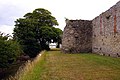
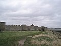
The fort is one of the best-preserved Roman fortifications on the Saxon coast in Britain and Western Europe and was used continuously for over 16 centuries. Although the fortress is mainly known for its Norman castle and church, its outer walls are mostly still Roman originals. The classic, rectangular floor plan with rounded corners (playing card shape) and the - for late antique camps - unusual design of the western and eastern gate systems are striking. The fort area itself covers an area of approximately 3.43 hectares.
The construction features of the defensive walls correspond to the fortress construction school of the late 3rd century. Similar to Pevensey , the wall ring, which is up to 200 m long, is very solid and robust. It still reaches a height of around six meters, a width of 3.8 m at the base and tapers in steps upwards. The cladding and cast mortar core are made of sandstone or broken flint, while the horizontal strips of flat sandstones or bricks used to strengthen the facing extend very deep into the wall. The original (Roman) wall technique can still be seen clearly, especially on the south wall. The weir system was also surrounded by two pointed trenches.
Gates and towers
Four gates break through the wall, the West (Landgate) and East (Watergate) are almost identical and each have two guard rooms, while the passages on the north and south walls are just simple gates without additional protective structures. The former east gate (porta principalis dextra) of Portus Adurni had a passage about three meters wide, covered by a multi-storey guard room, and was set back from the wall. This created a small forecourt / kennel (13.75 m wide x 11 m long), which enabled the defenders to fire the attackers from three sides. The two floors of the guard house were ventilated by three arched windows each on the east and west sides. This - actually outdated - door type was not found very often in forts of late antiquity. It is strongly reminiscent of the wood-and-earth gate systems from Augustan times, which also had a forecourt at their entrance. Its construction is in stark contrast to the protruding U-towers on the lake side. The two main gates were rebuilt in the 14th century. Originally the wall and its corners were reinforced by 20 protruding, semicircular towers (U or horseshoe towers), 14 of which have been preserved to this day. Hollow today, in late antiquity they were almost completely filled with cast masonry up to the tower crown.
Interior constructions
The Roman remains inside the fortress were largely destroyed by centuries of agricultural activity and later settlement, only several buildings from the Anglo-Saxon period could be excavated. The St. Mary Church in the southeast corner is the only surviving building of a short-lived Augustinian monastery, which was founded there around 1128. Excavations in 1965 uncovered a graveled main street and a few remains of wooden buildings from the late 3rd century, all from the time of Carausius , as shown by coins. Sewers and the general design of the systems suggest a total of four smaller wooden buildings. Furthermore, there were remains of regular buildings with wooden buildings that began in the middle of the 4th century. Later floors were laid on artificially created leveling layers. After 365, however, the development became more irregular and can hardly be seen. Traces of smaller workshops, in which metals and antler remains were processed, and a butcher's shop could also be observed.
garrison
Under the rule of the usurper Carausius, the fort temporarily served as the headquarters of the Classis Britannica . The Limitanei unit stationed here is only known from the Notitia Dignitatum (troop list of the Comes litoris Saxonici per Britanniam ), in which a Praepositus numeri exploratorum, Portum Adurni , d. H. "The commander of a company of scouts in Portus Adurni" is stated. It is believed that the unit was originally stationed north of Hadrian's Wall and consisted of horsemen. In the course of the reorganization of the border defense under Valentinian I , they were moved to the Saxon coast in 367.
Roman inscriptions that could provide information about other units stationed here have not yet been found. Excavations have shown that in the 4th century the garrison consisted mainly of Germanic tribes who lived in the fort with their families. Whether units of the canal fleet (Classis Britannica) were permanently stationed in the port of the fort after the relocation of the fleet headquarters under Allectus, even after the end of his rule, is not known, but due to the location of the fort it is very likely.
- Portus Adurni Gallery

Bird's eye view

Western wall

West Gate (Landgate)

East Gate (Watergate)

View of the east wall

Bach near the Assheton's Tower

Tower of the south-west corner


U-tower on the north wall

South wall

View of the south wall

South wall

U-tower in the west wall

Norman castle
St. Mary's Church behind the fort wall


literature
- Nic Fields: Rome's Saxon Shore Coastal Defenses of Roman Britain AD 250-500 (= Fortress. 56). Osprey Books, Oxford 2006, ISBN 978-1-84603-094-9 .
- RG Collingwood : The Archeology of Roman Britain. Methuen Publishing House, London 1930.
- Barry Cunliffe: Excavations at Portchester Castle. Volume I, Roman, Society of Antiquaries Research Report No. 32, London, 1975.
- Barry Cunliffe: Excavations at Portchester Castle, Volume III, Medieval, the Outer Bailey and its Defences, Society of Antiquaries Research Report No. 34, London, 1977.
- Barry Cunliffe: Excavations at Portchester Castle, Volume IV, Medieval, the Inner Bailey, Society of Antiquaries Research Report No. 43, London, 1985, pp. 183-204.
- Barry Cunliffe: Excavations at Portchester Castle, Volume V, Post Medieval 1609-1819, Society of Antiquaries Research Report No. 52, London, 1994.
- R. Liddiard: Anglo-Norman Castles. In it: A Williams: A bell house and a burh-geat: lordly residences in England before the Conquest. Woodbridge, 2003, pp. 23-28.
- Michael DuBois: Auxillae. LuLu.Com 2015.
Web links
- Fort Portus Adurni at Roman-Britain.org
- Portus Adurni on PASTCAPE
- Portus Adurni on CastlesFortsBattles
- Reconstruction drawings of the fortress
- English Heritage: Reconstruction drawing of Portchester in the 10th century
- Portchester on English Heritage
Remarks
- ^ Geographer of Ravenna 43.
- ^ Matthias Springer: The Saxons . Kohlhammer, Stuttgart 2004, ISBN 978-3-17-016588-5 , p. 33.
- ^ Collingwood, p. 53.
- ^ N. Fields, 2006, p. 27.
- ↑ Jürgen Oldenstein : Alzey Castle. Archaeological investigations in the late Roman camp and studies on border defense in the Mainz ducat. Habilitation thesis Universität Mainz 1992. Online edition Mainz 2009, pp. 261–262 ( online ).
- ↑ Notitia Dignitatum XXVIII.21; DuBois 2015, p. 275.