
Noviomagus Regnorum

Noviomagus Regnorum (also Noviomagus Reginorum ) was a Roman city in the province of Britannia , from which today's Chichester emerged. After the Roman conquest in 43 AD, the place was briefly a military camp and then the residence of the vassal king Tiberius Claudius Cogidubnus . During this time, a planned expansion to the city took place, and Noviomagus Regnorum became the capital, from where Tiberius Claudius Cogidubnus ruled over the Celtic tribe of the Regni (also called Regnentes ). The remains of a forum , an amphitheater and monumental thermal baths give evidence of this main location in Roman times . Noviomagus Regnorum was probably abandoned in the fifth century. Settlement by Anglo-Saxons is documented from the seventh century. Because of the development of Chichester, which began at that time and was continued and preserved throughout the Middle Ages , excavations have so far only been carried out to a very limited extent, so that little concrete is known about the ancient city.
Surname
The city appears with slightly different names in the ancient sources. In the Itinerarium Antonini it is simply referred to as Regno , in the geographer of Ravenna as Noviomago Regentium . Claudius Ptolemy (I, 15, 7; II, 3, 13) calls them Noiomagos ( Νοιόμαγος ; in the accusative: Νοιόμαγον ) and describes them as the city ( polis ) of the Regni . The meaning of the name is uncertain. Noviomagus may mean the new market or the new city in Celtic . Regni perhaps goes back to Latin Regnum (= kingdom) and may indicate that the Regni were once part of a vassal kingdom. This term could also go back to the Celtic word regini (= the proud). Accordingly, the name of the city can mean The New City of the Proud or the New City of the People from the Kingdom .
location

Noviomagus Regnorum is located in what is now West Sussex in the far south of England on the Lavant , a stream that is waterless in summer. It comes from the north and flows south of the city to the west, supplying it with water, but there were also numerous wells in it. Noviomagus Regnorum is located on a plain about ten kilometers from the English Channel . The soil there is a mixture of clay and pebbles. Two kilometers southwest of the city there is a bay that is now heavily silted up and thus forms marshland. There may have been a port here in ancient times. The Fishbourne Roman Palace is also located here . In the north, the South Downs join, a hilly landscape that is also used intensively for agriculture.
The city was the end point of four streets. In the north a road led to Calleva Atrebatum ( Silchester ), the main town of the Atrebats . In the east, Stane Street connected Noviomagus Regnorum with the provincial capital Londinium ( London ). Stane Street was one of the most important streets in Britain; its course has been well researched today. In the south a road led to Selsey , which was probably an important place by the sea, but little of the Roman remains has been preserved, as the ancient remains have been submerged in the sea by the progressive erosion of the coast. In the west the road led to Clausentum ( Bitterne ), an important port at the time. The course of the last two roads mentioned has so far hardly been explored.
As the capital of a civitas, Noviomagus Regnorum was the administrative and probably also the economic center of the region. The civitas likely encompassed large parts of what is now Sussex and perhaps the eastern part of Hampshire . In the north were the northern Atrebats with their main town, Calleva Atrebatum . To the west was Venta Belgarum ( Winchester ), which was the capital of the Belgians (the Atrebats were a part of the Belger tribe), whose civitas included the rest of Hampshire and parts of Wiltshire . Noviomagus Regnorum was not in the center of the civitas, but far to the west and relatively close to the sea. Other important locations were likely Hassocks and Pulborough , which perhaps also served as local centers for the other parts of the civitas.
In the vicinity of the city there were various villae rusticae , which at least in part had the task of supplying the city with food. To the west of the city was the Fishbourne Palace, which was initially probably a royal residence, but was taken over by other owners at the end of the second century and then served agricultural purposes. About five kilometers to the west was another settlement and a temple or shrine at Bosham . A larger temple also stood on Hayling Island ( Hampshire ) around 15 kilometers west of the city. About ten kilometers north there were two villas in the Chilgrove Valley ( Villa Rustica (Chilgrove 1) , Villa Rustica (Chilgrove 2) ) and another at Up Marden . About twelve kilometers northeast on Stane Street stood the large Bignor mansion , which must have been the seat of a wealthy family with large estates. This villa was expanded mainly in the fourth century and decorated with numerous mosaics.
history
The region in Celtic times
In the south of Britain lived in the first century BC. The Celtic tribe of the Atrebates . Their first known ruler was Commius . He was an ally of Gaius Julius Caesar and was appointed king of the mainland Atrebates by him, but turned against him and supported the Gallic uprising under Vercingetorix . The uprising was put down and Commius fled to Britain, where he managed to become ruler of the Atrebates there. After his death his sons followed him. Tincommius was the direct successor while Eppillus gained power in Kent . After the death of Tincommius, Verica , another son of Commius, ascended the throne. He bears the title rex (king) on his coins , which indicates that he was a vassal of the Romans. His territory seems to have been threatened by the ruling tribe of the Catuvellaunen in the north , who pushed Verica ever further south. Verica, who had his dominant center around Noviomagus Regnorum, asked the Romans for help, who saw it as a welcome pretext for invading Britain (43 AD). They managed to conquer large parts of the country.
Beginning of Roman rule
The beginning of the actual city history is uncertain. However, it is closely related to the events shortly after the conquest of Britain. The south and thus Noviomagus Regnorum were the first to come under Roman rule. During excavations in today's urban area, wooden buildings and Celtic coins were found, including those of the Celtic king Verica , which suggest an Iron Age predecessor settlement, but not really evidence. At the “Cattle Market” three round huts came to light, which probably did not belong to a previous settlement, but to an Iron Age homestead. It can be assumed that the first Roman settlement was military in nature and dated shortly after the conquest of Britain. Excavations in the north-western part of the city have uncovered barrack-like wooden structures. The finds are clearly of a military nature; among them is a well-preserved sword ( gladius ) of the "Mainz type". This camp can be dated primarily using ceramics. Numerous terra sigillata shards were found. The earliest date from the reign of Emperor Augustus (30 BC to 14 AD) and were seen as evidence that there was a Celtic settlement here before the Roman camp. However, it is also possible that this ceramic was simply in use for a long time. Other ceramics testify that the camp was abandoned no later than 44 or 45 AD. Outside the ancient city walls, trenches have been discovered that may belong to this military camp. The Legio II Augusta may have been stationed here before it was moved to Calleva Atrebatum ( Silchester ). The Legio II Augusta , along with two others, took part in the conquest of Britain. Remains have also been found in nearby Fishbourne , indicating such an early military presence. At Fishbourne there were evidently the port and stores that supplied the warehouse at Noviomagus Regnorum. Both places may have formed one of several bridgeheads during the conquest of Britain.
After the troops withdrew, the camp was abandoned and more solid structures were erected, but they were still mainly made of wood, although they had flint foundations. During this time there was a pottery and a metal workshop in the city. A longer inscription from AD 58/60 comes either from a public building or from the base of a statue. The inscription was found and copied in 1740, but is now lost. But it shows construction work for these years:
- Neroni
- Claudio divi
- [Claudi f (ilio) G] ermani [ci Caes] -
- [aris n] epoti Ti (beri) [Caes (aris)]
- [Aug (usti) p] ronepoti div [i Aug (usti)]
- [ab] n (epoti) Caesari Aug (usto) [Germ (anico)]
- [t] r (ibunicia) p (otestate) IV imp (eratori) IV co (n) s (uli) IV
- s (enatus) c (onsulto) v (otum) m (erito)
Translation: "For Nero Claudius Augustus Germanicus, son of the divine Claudius, grandson of Germanicus Caesar, great-grandson of Tiberius Caesar Augustus, great-great-grandson of the divine Augustus, four times holder of tribunician power, four times emperor, four times consul, by resolution of the Senate".

During this period the south of Britain still had a special status and was ruled by a vassal king. Noviomagus Regnorum was perhaps the capital of the vassal king Tiberius Claudius Cogidubnus , the presumed successor of Verica. In the city there was an inscription with the name of Tiberius Claudius Cogidubnus and the mention of a temple for Neptune and Minerva . The ruler is otherwise only mentioned in Tacitus , according to whom he was familiar with Roman customs from an early age and was always loyal to the Romans. A little to the west of the city there was a monumental palace ( Fishbourne Roman Palace ), which was perhaps the residence of Cogidubnus. It is unknown how long this ruler ruled and when he died.
Noviomagus Regnorum as a suburb of a civitas
Very little is known about what happened after the death of Tiberius Claudius Cogidubnus. No successor was apparently appointed as the Flavian emperors tried to remove vassal royalty. It was probably during this time that the city was incorporated into the regular administration of the Roman Empire and expanded to become the Civitas capital of the Regni, as the southern Atrebates were now called. If not earlier, Noviomagus Regnorum has now received a city complex with streets crossing at right angles and other public buildings. At least the thermal baths in the city center were probably built during this time.
The first century inscriptions and early building activity in the city, especially when compared to other British cities, have been viewed as evidence of rapid Romanization. However, the evidence for this is not very abundant. After all, magnificent villas were built in the south of Britain at this time, which point to a strong Romanization. In other parts of Britain, such elaborate villas often only appeared in the fourth century. The city's population is believed to have come from Selsey, which is located directly on the coast about ten kilometers south of Noviomagus Regnorum and where a Celtic oppidum is suspected.
From the end of the first century to the third century Britain and the whole of the Roman Empire saw a time of peace. Noviomagus Regnorum may have experienced a certain prosperity during this time. During these years other public buildings were built. The amphitheater dates back to the end of the first century. The thermal baths were expanded or at least renovated. It is uncertain when the forum was built. The third century, on the other hand, was a time of civil wars and wars against external enemies, which led to the city's economic decline. No new public buildings were erected during this time, but the city wall was probably only expanded in this century. Something similar is attested and documented for other cities in Britain; there, too, times were restless and uncertain. Otherwise you will not learn anything about the history of the city from ancient sources. It is mentioned by some ancient geographers. Inscriptions from the city that could provide further clues are rare.
The end of the Roman city
Little information is available about the late phase of the Roman city. The fourth century was marked by unrest in Britain. Excavations in the urban area show that the city was fully functional until the last quarter of the fourth century. The thermal baths remained in operation. There, tree trunks were found in a cistern that were felled on the basis of dendrochronological studies after 370 AD and, accordingly, repairs in the cistern date from this time. An excavated house was extensively expanded.
A letter from Emperor Flavius Honorius has come down to us from the year 410, instructing the inhabitants of Britain to look after the defense of their country themselves. In the fifth century, the Anglo-Saxons invaded the country and displaced the remaining Roman population. Fighting between the Romans and the newly arriving Anglo-Saxons is attested from the fifth century, but Noviomagus Regnorum is not mentioned in the sources. The city was on the front line of events because of its location near the sea. The last coins in the city area are struck by Valentinian II (375–392 AD). There are only two exceptions. A gold solidus from Emperor Valentinian III was found. which dated between 425 and 455 AD, but has not been found in any secured excavation. It is a Visigoth copy of a gold coin, which at least suggests such a late settlement. A coin of Arcadius was finally found in the urban area, dating from the year 408 AD. The place seems to have been inhabited in the 5th century. There is no evidence of Anglo-Saxon cemeteries in the vicinity of the city. This could be an indication that the city was able to defend itself against the newcomers for a long time. There are signs of slow deterioration in the apartment buildings that have been excavated in the city. New walls made of simple wattle were put in in one house. In the two better-excavated residential buildings, simple fire pits were found on the Opus Tessallatum floors. However, there are no signs of a violent ending. So far, however, there is also no evidence of settlement continuity from antiquity to the Middle Ages . In the Anglo-Saxon Chronicle the arrival of Ælle is mentioned for the year 477 (probably an error for 457) , who in the following years conquered parts of Sussex and thus probably also Noviomagus Regnorum. However, the city is not specifically mentioned in the sources. This may indicate that it was no longer important then.
The city was probably abandoned sometime at the end of the fifth century. There are no objects that date to the sixth century. In the seventh century the Saxons in the south of England were Christianized by Wilfrid . The region was now settled by Saxony and there are findings from the seventh century that indicate a new settlement in the urban area.
Excavation and research history
Chichester is now a small town with a well-preserved historic center. Accordingly, new houses are very rarely built, which in turn gives archaeologists little opportunity to dig over large areas within the city. Road construction works, where larger areas can be covered, are an exception. Individual Roman finds were and are made again and again. In 1723 the inscription of Tiberius Claudius Cogidubnus was found, which immediately attracted attention as it names a historically known person. The inscription is still preserved today. In 1740 an inscription from the time of Nero was discovered, which is no longer preserved today, but has survived in a copy. Other finds - especially of buildings - in the 18th and 19th centuries are often only known as vague descriptions. In the 18th century, for example, a house with a particularly large mosaic (9.1 m square) was uncovered in the garden of the bishop's palace. The first systematic excavations were carried out in 1934 by Gladys Maud White - later wife of Grahame Clark - who tried to locate the city's amphitheater and found it. However, they were only able to carry out very limited excavation cuts, which confirm the location of the building, but leave many questions unanswered.
In 1947 the Chichester Civic Society Excavations Committee was formed. It set itself the task of researching the city's early history and was active until 1979. In 1985 the Chichester District Archeology Unit was founded, which now oversaw the excavations in the city. In 1994 it merged with the York Archaeological Trust and became Southern Archeology . This organization ceased its work in 1998. The Chichester & District Archeology Society was founded in 1991 and has since led excavations in and around the city.
John Holmes examined parts of the city wall in 1959 and also wrote a small monograph on the Roman city. From 1958 to 1986 Alec Down (1914–1995) worked in and around the city , whose life's work was the exploration of the city. In the center of the city, barracks between "Tower Street" and "Chapel Street" were demolished from 1962 to 1964. This gave the opportunity to capture a larger section of the ancient city. Two houses and the thermal baths were excavated. Wooden buildings from a military camp emerged as the bottom layer. A pedestrian zone was set up in the center of the city in the 1970s, which made further excavations under the road surface possible. Further rescue excavations at the “Theological College” and east of the ancient city walls gave the chance to systematically excavate parts of the suburbs and, above all, larger sections of the cemeteries. Alec Down published his excavations, which also include medieval and modern findings, in several volumes. He also evaluated older findings in the publications.
The town
Residential buildings
The walled urban area was about 39 hectares. Only a few buildings are better known because of the current development in the urban area. The parts of the building exposed during modern construction work are often very small and offer little information. These litter finds show that the first buildings were mostly made of wood. It was not until the second century that stone buildings became more common. So could z. For example, under St. Andrews Church in "Church Lane" a Roman wall and a floor are cut with Opus tessellatum , which probably date to the second century. There were also loose pieces of the mosaic that indicate that a house of wealthy citizens stood here. To the north of the city center, the remains of two residential buildings have largely been excavated. Both houses were built in the second century and were used until the end of the fourth century. The northern of the two buildings had a courtyard that opened onto the street. It has been rebuilt and expanded several times. Up until the beginning of the fourth century it was a wooden structure. Around the middle of the fourth century the stone building was expanded. At the end of the fourth century he had at least four rooms with floors in opus tessellatum. It was also during this period that it received new, firmer foundations, suggesting that the house was likely built entirely from stone and perhaps even had a second story. In 2017 and 2018, the remains of a large residential building with a bathing facility were uncovered.
Mosaics
So far, seven remains of mosaic floors have been found in the urban area, which indicate a high standard of living, at least in parts of the city. They are decorated exclusively with geometric patterns. A polychrome, geometric mosaic was found under the city's medieval cathedral, possibly dating to the second century AD, as ceramics from the second century were discovered under the mosaic. Nearby, another fragment of a mosaic floor with a pattern of swastikas came to light. In the area of the thermal baths, a fragment of a black and white mosaic, which probably dates back to the first century, was excavated. The mosaic is stylistically related to that of the Fishbourne Roman Palace and may even come from the same craftsman. Two other polychrome mosaics were found in the center of the city and probably date to the second and fourth centuries. Another mosaic fragment comes from a house excavated in the city center, which is only very small and also shows a polychrome pattern.
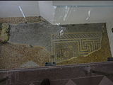
Fragment of a mosaic floor found under the cathedral

Fragment of a mosaic floor from a house in the north of the city


Public buildings

The forum was probably located in the center of the city . Here parts of a massive foundation wall came to light, which may be a stylobate (a step foundation). It may belong to the forum or the associated basilica. In the center of the city there was also a large square made up of a layer of crushed stone that leveled older structures. The function is unknown, but the area is too large to be the forum.
Between 1960 and 1962, parts of the thermal baths were excavated in "Tower Street", west of the forum , which probably occupied an entire insula in the center of the city. The complex was once around 65 × 80 meters, but the remains are severely disturbed by medieval and modern buildings. In the north were the actual bathing rooms, while in the southern part a palaestra (ring square) is assumed. Some walls were up to 1.5 meters wide. Several construction phases can be seen on the structure. The archaeological findings showed that the thermal baths were probably built in the Flavian period and expanded in the early 2nd century. In the period that followed until the end of the 4th century, the building was redesigned several times. The rooms themselves were richly decorated, with traces of plastered and painted walls, colored marble paneling and some floors with mosaic and opus sectile . One room dated to the 4th century had an apse, while several rooms had hypocausts . In the north of the thermal baths there were remains of water pipes and in the west there was a cistern that reached deep into the ground and the water table. A pump, which was still being repaired at the end of the fourth century, brought the water from there into an adjacent basin.
Temples are known only from inscriptions or individual components. The above-mentioned inscription by Tiberius Claudius Cogidubnus shows a temple for Neptune and Minerva. Massive walls that may have come from the temple have been found near the inscription. In 1934 there was also a column base with an inscription to Jupiter Optimus Maximus from the 2nd century in "West Street" (where the post office is now located) . A third inscription is a dedication of a treasurer (arcarius) to the mother goddesses of the homeland.
The amphitheater stood outside the city wall in the east . The arena was elliptical in shape and was 56 meters long and 47 meters wide. It was about 1.2 meters below the contemporary floor. The amphitheater was probably built at the end of the first century, but perhaps abandoned by the end of the second century. However, only small parts of the theater have been excavated, so these dates remain somewhat uncertain.

Ruins of the thermal baths

The apse in the thermal baths, with hypocausts
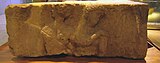
Fragment of a column base in the temple with an inscription dedicated to Jupiter Optimus Maximus

The place of the amphitheater, which can still be seen today as a slight hollow in a meadow.


city wall

The city had a city wall with an approximately trapezoidal shape. It consisted of the actual wall with a ditch and a pile of earth on the inside. The date of its construction is uncertain. In other cities in Britain, the city walls were extended or even erected in the third century, which may also be the case here, but excavations have revealed trenches that may belong to an earlier defensive work. The later wall was made of flint and shows numerous signs of restoration in the few places where it was excavated. At the base it was about 2.4 meters wide and in some cases still towers 2.4 meters high. There were various bastions that belonged to a later construction phase. The city wall is now fully integrated into that of the Middle Ages. The Roman wall is therefore no longer visible today, while the medieval wall is still well preserved. The wall once probably had four gates, which were roughly in the place of the medieval gates. However, this could only be partially confirmed by excavations. Some gates still stood in the 18th century and are known from old drawings. Parts of the south gate have been excavated. However, the remains are too small to be able to make reliable statements about the construction. It is possible that the actual gate was flanked by two guard rooms.
Suburbs
The built-up urban area was not only limited to the area within the city walls, but there is also evidence of building beyond the wall. There were suburbs mainly in the north, east and south. During excavations in front of the east gate in particular, wooden buildings dating from the first to the fifth century could be recorded. There is also evidence of iron processing here. In the north there is evidence of wooden, but also stone buildings that date to the fourth century. Outside the south gate, too, there seems to have been a loose development with wooden structures. Here, too, slag points to a forge.
Craft and trade


Noviomagus Regnorum was close to the sea and in a region that has been used intensively for agriculture since ancient times. Accordingly, the main products of the region are likely to have been various agricultural products, salt and fish. They were probably produced not only for local consumption but also for export to other parts of Britain and the Roman Empire. The discovery of an iron emasculator (a castration device) testifies to livestock farming in the city. All other industries, on the other hand, seem to have covered local needs in the city and the surrounding area. Excavations testify to a pottery that was in operation in the city in the first century shortly after the military left. Two ceramic kilns could also be excavated. They date from the reign of Emperor Nero . The ceramics produced here are of high quality. At the same time, a blacksmith was working in the city, who probably specialized in jewelry. Several hundred small crucibles were found. Evidence of iron processing was found particularly in the suburbs. Other industries can only be developed without there being any direct evidence of production in the city. This includes, above all, the processing of bones into everyday objects, but also the construction industry. Roof tiles were certainly used on a larger scale.
During the excavations in the city, many objects were found that were certainly not produced in the city and show that many goods were imported into the city. These are often products of higher quality. Above all, there were large quantities of terra sigillata , high quality ceramics that were produced in Italy and then in Gaul and exported to other parts of the empire. Italian wine amphorae are documented for this area as early as pre-Roman times and testify to the import of wine.
Necropolis


According to Roman law, burials were only allowed outside of a place. Accordingly, cemeteries are a good guide to the extent of a settlement. Exceptions were apparently newborn burials, which could also be carried out in the settlement area. At the east gate, within the city wall, there were twelve burials of newborns in a settlement context of wooden buildings. It was suspected that they were founding victims. Four cemeteries are attested. Two of them are outside the east gate (at and south of St. Pancras Church), another beyond the north gate, and a fourth beyond the west gate. The cemetery on the street “St. Pancras ”(which runs along Stane Street ) is the largest known to date. 326 burials could be excavated, but the whole cemetery should once have numbered around 9,500 to 10,000 burials. Most of them are urn graves, only nine body burials are attested. Most of the burials had no grave goods. Only one urn was found with the ashes. The other burials had at least some additions. Mostly it is about eating utensils. Most of the other grave goods were damaged objects that were either deliberately broken for burial, or objects that were no longer usable were deliberately selected. The cemetery was probably mainly used from the first to the beginning of the fourth century. Around every tenth burial had lamps as accessories, which often show little signs of use and were perhaps bought especially for the funeral. 14 body burials are known from the cemetery at St. Pancras to the south. There were only a few additions. Nails show that at least some of the dead were buried in wooden coffins. The cemetery probably dates back to the fourth century. The cemetery outside the west gate was also likely used mostly in the fourth century. 59 burials could be examined, two of them in a lead coffin. This cemetery is located in an area that previously housed residential buildings, but which were abandoned at a certain point in time. Only three inscribed gravestones are known, two of which were found at the south gate and may have been used again here. One bears the inscription:
- [] cca Aelia
- [- - -] Cavua
- [- -] fil (ia) an (norum) XXXVI
what can be (supplemented) and translated:
- "Boudicca Aelia of the Cauvan tribe, daughter of ..., 36 years old"
The inscription on a second tombstone reads:
- Catia
- Censorin [a –––]
- an (norum) XXIII [–––]
- "Catia Censorina ..., 23 years old"
A third tombstone is lost today:
- [D (is)] M (anibus)
- [–––] nus At-
- [–––] arius
- [vix (it) an (nos)] LXXXV
- “The gods of the dead. ... nus At ... arius, was 85 years old. "
Visible remains in today's city
Few ancient remains have been preserved in today's cityscape. The amphitheater forms a hollow in a small park. The place is signposted. The inscription of Tiberius Claudius Cogidubnus is embedded in the facade of the historic meeting house in "North Street". Part of a mosaic floor was found next to Chichester Cathedral in 1966 , has been left in place and can be seen through a pane of glass in the floor. The medieval city wall, which is still well preserved today, houses a Roman core. However, the parts that are still visible all date from the Middle Ages. Remnants of the thermal baths can now be seen in the cellar of the local museum, the Novium . Before that, they had been preserved as a floor monument under a parking lot. The museum is a new building opened in 2012, the work of Keith Williams' architectural office, which also planned the Opera House in Wexford (Ireland) and the Unicorn Theater in London . The history of this museum goes back to the year 1831, from 1962 it was located in a disused flour mill in Little London. Its holdings in the exhibition and collection include around 150,000 artifacts.
literature
General
- Barry Cunliffe : Noviomagus Regnensium (Chichester) Sussex, England . In: Richard Stillwell et al. a. (Ed.): The Princeton Encyclopedia of Classical Sites. Princeton University Press, Princeton NJ 1976, ISBN 0-691-03542-3 .
- Alec Down: Roman Chichester. Chichester 1988, ISBN 0-85033-435-7 .
- David Rudling: Roman-Period Temples, Shrines and Religion in Sussex. In: David Rudling (Ed.): Ritual Landscapes of Roman South-East Britain. Oxford 2008, ISBN 978-1-905223-18-3 , pp. 95-137.
- John Wacher: The Towns of Roman Britain. Routledge, London / New York 1997, ISBN 0-415-17041-9 , pp. 255-271.
- John Magilion: The defenses of Roman Chichester. In: The archeology of Roman towns. Studies in honor of John S. Wacher. Oxbow, Oxford 2003, pp. 156-167.
Excavation reports
- Alec Down, M. Rule: Chichester Excavations 1. Oxford 1971.
- Alec Down: Chichester Excavations 2-6. Chichester 1974-1989.
- Alec Down, John Magilton: Chichester Excavations 8. Chichester 1993.
Web links
- Noviomagus Regnorum (English)
- The Novium - Museum and Tourist Information (English)
Individual evidence
- ^ ALF Rivet, C. Smith: The Place Names of Roman Britain. London 1979, ISBN 0-7134-2077-4 , p. 427.
- ↑ Barry Cuncliffe: Fishbourne, A Roman Palace and its Garden. London 1971, ISBN 0-500-27015-5 , p. 26.
- ^ Down: Roman Chichester. Pp. 48-51.
- ^ Down: Roman Chichester. P. 82f.
- ^ Down: Roman Chichester. Pp. 82-99.
- ^ Down: Roman Chichester. P. 5.
- ^ Down: Roman Chichester. Pp. 7-14; on the sword see: Graham Webster: A Gladius from Chichester , in A. Down: Chichester Excavations 5 , p. 173, fig. 8.28, no.1.
- ^ Down: Roman Chichester. Pp. 14-16.
- ^ David JP Mason: Roman Britain and the Roman Navy. Stroud 2003, ISBN 0-7524-2541-2 , p. 85.
- ^ Down: Roman Chichester. P. 18.
- ↑ CIL 7, 12 = Roman Inscriptions in Britain 1, 9. See Down: Roman Chichester , p. 22.
- ↑ CIL 7, 11 . Epigraphic database Heidelberg .
- ^ Down: Roman Chichester. P. 24.
- ^ Wacher: The Towns of Roman Britain. P. 27.
- ^ Down: Roman Chichester. P. 101.
- ^ Down: Roman Chichester. Pp. 102-103.
- ↑ Ken Dark: Britain and the End of the Roman Empire. Stroud 2000, pp. 100f.
- ^ Down: Roman Chichester. P. 104f.
- ^ Down: Roman Chichester. P. 105f.
- ^ Chichester Excavations Committee ( September 1, 2012 memento in the Internet Archive )
- ^ Southern Archeology ( Memento of September 1, 2012 in the Internet Archive )
- ^ Chichester & District Archeology Society
- ^ J. Holmes: The Defenses of Roman Chichester. In: Sussex Archaeological Collections 100 (1962), pp. 80-92.
- ^ J. Holmes: Chichester, the Roman Town. (Chichester Papers 50), Chichester 1963.
- ^ David Mattingly : An Imperial Possession: Britain in the Roman Empire, 54 BC - AD 409 , London 2007, ISBN 978-0-14-014822-0 , p. 268.
- ↑ Down: Chichester Excavastions 5. 1981, pp. 2-5.
- ^ Down: Roman Chichester. Pp. 34-36; Wacher: The Towns of Roman Britain , p. 268.
- ↑ Private Roman bath house is found under city park Truly exceptional 'Roman bath house uncovered in Priory Park, in Chichester District Council
- ↑ Chichester Priory Park dig unearths 'Roman hot tub' remains, BBC
- ^ David S. Neal, Stephen R. Cosh: Roman Mosaics of Britain, Volume III: South-East Britain, Part 2. London 2009, ISBN 978-0-85431-289-4 , pp. 514-519.
- ↑ Down: Chichester Excavations 5. 1981, pp. 51-55.
- ^ Down: Roman Chichester. P. 41.
- ↑ Down: Chichester Excavations 3. Old Woking 1978, p. 17.
- ↑ AE 1935, 7 = Roman Inscriptions in Britain 1, 89. The Novium - Object of the month: Jupiter Stone ( Memento of October 29, 2013 in the Internet Archive ); accessed January 4, 2013; the date of the inscription is uncertain and the 1st century has been suggested; see: Rudling, in: Ritual Landscapes , pp. 98-100.
- ↑ AE 1979, 381 = Roman Inscriptions in Britain 3, 3037: [Matri] bus Domest (icis) / [---] us ark (arius) / [d (e) s (uo)] p (osuit) . See Down: Roman Chichester , pp. 23-24.
- ^ GM White: The Chichester Amphitheater: Preliminary Excavations. In: Antiquaries Journal 16 (1936), pp. 149–159.
- ^ Wacher: The Towns of Roman Britain. P. 265.
- ^ Wacher: The Towns of Roman Britain. Pp. 265-266.
- ↑ Down: Chichester Excavastions 5. 1981, pp. 41-44.
- ^ Down: Roman Chichester. Pp. 30-40.
- ^ Down: Roman Chichester. Pp. 72-82.
- ↑ Rudling, in: Ritual Landscapes , p. 101.
- ^ Down: Roman Chichester. Pp. 59-66; A. Down, M. Rule: Chichester Excavations I , Oxford 1971, pp. 53-126.
- ↑ Down: Chichester Excavations 5. pp. 90-95.
- ^ Down: Roman Chichester. P. 65.
- ↑ CIL 7, 13 = Roman Inscriptions in Britain 1, 94, printed there without the first opening interpolation bracket.
- ^ Down: Roman Chichester. P. 65.
- ↑ CIL 7, 15 = Roman Inscriptions in Britain 1, 95.
- ↑ CIL 7, 14 = Roman Inscriptions in Britain 1, 93.
- ^ Down: Roman Chichester. Pp. 65-66.
- ^ Roger JA Wilson: A Guide to the Roman Remains in Britain. Fourth Edition, Constable, London 2002, ISBN 1-84119-318-6 , pp. 65-68.
- ↑ Chichester's Novium Museum ( Memento of the original from July 28, 2013 in the Internet Archive ) Info: The archive link was automatically inserted and has not yet been checked. Please check the original and archive link according to the instructions and then remove this notice. ; Retrieved January 4, 2013.
- ↑ The Novium. ( Memento of January 2, 2013 in the Internet Archive ) Retrieved January 4, 2013.

Caesaromagus | Calleva Atrebatum | Corinium Dobunnorum | Durnovaria | Durobrivae | Durovernum Cantiacorum | Eboracum | Isca Dumnoniorum | Isurium Brigantum | Lindinis | Luguvalium | Moridunum | Noviomagus Regnorum | Ratae Corieltavorum | Venta Belgarum | Venta Icenorum | Venta Silurum | Verulamium | Viroconium
Coordinates: 50 ° 50 ′ N , 0 ° 47 ′ W