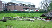
Durnovaria
Durnovaria is the ancient name of Dorchester in England . It was the capital of the civitas of the Durotriges , a Celtic tribe. Probably in the second century AD the civitas area was divided and Lindinis became the capital of the other part. Durnovaria lies on the Frome and was well connected to the sea.
Durnovaria was developed into a Roman city with right-angled streets and public buildings in Flavian times . There may have been a military camp in the same location, but it has not yet been possible to locate it with certainty. Because of the modern development, however, it is difficult to get a complete picture of the ancient city. The city was roughly square in plan and about 500 × 500 meters in size. In the northeast, the city bordered the Frome, so that the corner of the city square is practically "cut off" here.
There was a city wall with probably four gates. The wall was probably not built until the late second century and reinforced around 300 AD. For the water supply there was an aqueduct that entered the city at the west gate.
In the south, outside the city wall, an amphitheater could be discovered that was built into a Neolithic rampart (see: Maumbury Rings ). It is relatively large with an outer diameter of around 100 meters. There was a bath in the south of the city. The city initially consisted mostly of wooden houses. It was not until the second century that these were replaced by stone ones. A villa-like house in the north-west of the city was richly decorated with mosaics and has largely been excavated. Other residential buildings were mostly only partially cut into during construction work in the city. What is striking is the large number of over 60 mosaics that were found in the city and indicate great prosperity.
Outside the city, various cemeteries could be observed and partially excavated. The city was abandoned during the fifth century AD.
Individual evidence
- Jump up ↑ Stephen R. Cosh, David S. Neal: Roman Mosaics of Britain, Volume II, South-West Britain , Barham, London 2005 ISBN 978-09547916-1-2 , pp. 86-122.
literature
- John Wacher: The Towns of Roman Britain , Routledge, London / New York 1997, ISBN 0-415-17041-9 , pp. 323-335.
Web links
Coordinates: 50 ° 42 ′ 38.5 ″ N , 2 ° 26 ′ 2.4 ″ W.

